Posted: May 13th, 2010 | No Comments »
There is an unwritten rule when fast prototyping that says that “one should know when to stop”. It is executed making up a deadline, fixing a scope and sticking to them. Last week’s Lift Conference marked the end of a fast prototyped pet project that contributed to this year’s theme “connected people” with an interactive map of Geneva from its social network activity.
The result highlights photogenic areas (e.g. lakefront, old town, parks) and events (Geneva Motor Show, Geneva Festival) based on the analysis of 3070 photos georeferenced by 1237 Flickr users over a full year. These persistent longitudinal measures (see Adam Greenfield’s description of the Long Here) are overlaid with the location of the most checked-in places in Foursquare within the week of the Lift Conference (see Adam Greenfield’s description of the Big Now). This (almost) immediate checkin-in trend acted as invitations to explore or rediscover Geneva.
This work is now archived (see Geneva From its Social Network Activities) and the milestones documented in Flickr.
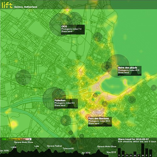
Through data analysis and visualization techniques, we produced an interactive map of the city, revealing photogenic areas (e.g. the lakefront) with public places (e.g. Bains des Pâquis, Parc des Bastion) and events (e.g. Geneva Motor Show, Geneva Festival, and of course Lift at CICG) people like to share online. Screenshot of Friday May 7, 2010, at the end of the Lift conference that took place at CICG in Geneva.
During the conference, I was asked a several times for the reasons and the technicalities behind the development of this prototype.
My approach to fast prototyping looks further than building preliminary models or patterns later applicable to full-scale developments. Instead, I integrate fast prototyping to my hybrid research process in which the exploration equals the value of the result. Indeed, prior to any result, the prototype helps support the reasons of the investigation and build arguments of its significance. More concretely, if I ever had to legitimize this work, here are a few details on the “why” and how” I have developed this visualization:
Prototyping to learn new skills and techniques
A first reason to prototype is to learn something, particularly in the development of new skills and techniques. In favorable fast prototyping conditions there is a dose of freedom that do not constraint to particular technologies. In this project, I explored what I believed where the best techniques to build each element of the data visualization. In details:
Data collection:
I integrated my pre-existing Java module to connect to the Flick API with the flickrj library. The Foursquare data were regulatory collected with a simple Python scripts that used the Python Library for the Foursquare API.
Data management and analysis:
A banal MySQL database fed data to R, a statistical software that no one never masters enough. In addition to my current set of scripts, I particularly toyed with the ggplot2 plotting system to work on the heatmap (see ggplot2: Quick Heatmap Plotting). I also thoroughly browsed the R Spatial Projects with to find attractive graphic solutions, but ended up using filled.contour because it was producing the most detailed results. As part of my idea to reveal Foursquare territories, I employed the tripack package to produce Voronoï “maps”. I abandoned this exploration after two iterations, as the maps and concepts were too hard to understand (see below)
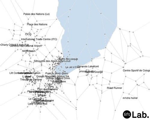
A tentative map of Foursquare “territories” in Geneva, using a Voronoï diagram produced with R (slightly skewed?) using the location of the most active places (more than 10 checkins not produced by the mayor).
Data interoperability:
The use of multiple technologies and programming languages forces the definition of XML Schemas to exchange data (when not using plain CSV files). Here I had to build my own schema as I am still looking for a proper schema for spatio-temporal data interoperability.
Data visualization:
This was the opportunity to get more familiar with the limits of the Flex graphics package, in comparison to what could have been done in Processing, particularly with the integration of a map. In this project, I was looking for an alternative to ModestMap (that I employ in other mapping projects) for a maximum freedom with different types of overlays. I toyed with the open source flex component HeatMap with time missing to produce a compelling solution. As a result, and for or simplicity reasons I ended up producing the Flickr heatmap with R.
Prototyping to surface problems
A part of the learning process is to understand the limits of a particular approach. As any user-generated content, the Foursquare dataset is particularly challenging because it contains inconsistencies that request manual data polishing, problematic when the solution must scale. The Foursquare API limit is another problem that can prevent from scaling-up from Geneva to another urban area with richer public activities. The workaround for this prototype was to solely analyze the 200 most active non-private “places”.
Prototyping to convey a message
A tangible and concrete example is a sure medium to communicate an investigation and its intentions. In this prototype, I want to first further emphasize the presence of spatial data from the use of social networks, that, when analyzed, can describe an city or a space. Second, these data have a temporal dimensions (historical for Flickr and immediate for Foursquare) as described by Adam Greenfield in The Long Here and the Big Now (see his talk at Lift). Third, beyond mapping data and the beauty of maps, I want to move the investigation to the development of quantifiable indicators that contribute to qualify a city, its spaces and its events (think of a form of Geodesign). The photogenic index that analyses the activity of photographers for an area and event is example in that direction. Finally, the imperfection of the results also highlight the limiting scope of the quantitative data analysis (see The “Quants”, their Normalizations and their Abstractions).
Prototyping to collect feedback
A prototype – even at an early stage – acts as an invitation to discuss opinions and criticize a concept. I apply an iterative process to fast prototyping that involves an increasing amount of pairs of eyes at each loop. The key is to make the object of development just good enough to understand and attract people, but never too polished in order to keep the options open. This iterative process with constant feedback helps each actor’s discourse to develop and helps frame further investigation. In this project, I received the first feedback on the graphic design of a spatio-temporal visualization that I serve for other projects.
Why do I blog this: I tried to provide answers the questions on the purpose of prototyping for Lift 10. Allocating time for fast prototyping is part of my research practice. It feed the development of other (more internal) projects that often involves more constraints and a limiting scope. I also recommend these rules to building prototypes written by Tristan Ferne.
Posted: May 5th, 2010 | 1 Comment »
These past days I have been working with my Lift Lab colleagues on a pet project for Lift 10 that aimed at providing an unusual map of Geneva. Here is the spiel as posted on the project page Geneva From its Social Network Activities:
The Lift Conference series has covered several themes on the digitization of the contemporary cities. In 2009, Dan Hill argued that the way citizens and visitors live and feel the urban environment is beginning to be profoundly affected by new information layers. Carlo Ratti showed us new ways of sense making of this deluge of information through data mining and visualizations techniques. For this year’s edition, Lift Lab wanted to participate with a tangible contribution that leverage the emergence of new urban information layers.
We have been capturing the activity generated around various social networks (Flickr, Foursquare) in Geneva from the data available via these services API. Through data analysis and visualization techniques, we produced an interactive map of the city, revealing photogenic areas (e.g. the waterfront) with public places (e.g. Bains des Pâquis, Parc des Bastion) and events (e.g. Geneva Motor Show, Geneva Festival) people like to share online. The result shows these dynamic information layers with their spatial and temporal trends as invitations to explore or rediscover Geneva.
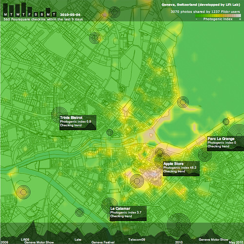
Snapshot of Geneva on May 4, 2010 (day before Lift10) revealing active places and their trends.
This kind of dynamic map exemplifies our recent investigations that leverage existing soft infrastructures (e.g. mobile phone networks, near-field communications, user-generated content) to create novel user experiences as well as refine the understanding of urban dynamics, mobility and occupancy levels. Over the years we have been engaged to produce techniques and prototypes for city governments (City of New York, Province of Florence), mobility service and infrastructure providers (Boeing, BitCarrier), mobile service providers (Orange R&D, Swisscom) and recently museum and exhibition managers (Le Louvre, Geneva Palexpo).
Why do I blog this: Besides prototyping something fun (and hopefully not frivolous), it was an opportunity to 1) refresh some of my pieces of code mixing R for data analysis, Java for data mining and back-end and AS3 for the front-end and 2) explore and experiment with new data manipulation techniques and R methods. Thanks to designer Maja Denzer for her informal advises at the beginning of the project. Here are the screenshots as testaments of the evolution of the interface.
Posted: April 21st, 2010 | No Comments »
The CNIL, an independent administrative authority protecting privacy and personal data in France recently gave an indulgent opinion on the RATP (the major transit operator responsible for public transportation in Paris) exploitation of billboards that measure their audience with video images (see Dispositifs d’analyse du comportement des consommateurs : souriez, vous êtes comptés !). The commission in charge of the matter suggested a “risk of individual tracking”, but their technical investigation insured that the data collected where rightfully anonymized and neither recorded nor disclosed to third parties, nor even seen by different providers. Their analysis also covered the exploitation of the data emitted by mobile phones to estimate people frequentation of certain areas and came to the conclusion that their encryption processes used were irreversible therefore ensuring anonymity.
The technical understanding of watchdog institutions is utterly precious to aliment and frame the debate on the exploitation of digital footprints. However, this news made me wonder whether the methods of the CNIL are not eventually counter-productive. Indeed its technical analysis of the matter is opaque and the measures not clearly formulated, raising speculations on its partisanship and seriousness. The lack of details on the types of data collected, the algorithms and anonymization process deployed by RATP forces citizens to depend on the sole CNIL to defend their rights.
In the days of sensors and crawlers intertwined with digital services, every single algorithm and data source that touch the common good should be scrutinized (like we do for every element of society). Nevertheless, I would argue that the different actors – including watchdogs – should contribute as part of a transparent process with an accountable set of rules. In this society made of multiple “oligopticons”, the concern is not only to make things visible (as argued for the panopticon), but rather to continue dealing the the opacity of information and politics (see In my World Information City Doggie Bag)
Why do I blog this: Keeping track of the evolution of the debate on the fair use of digital footprints (see The Application and Management of Personal Electronic Information).
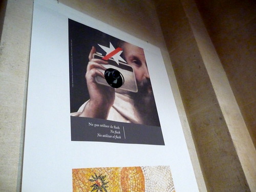
Camera embedded in a poster in Le Louvre, Paris.
Posted: March 30th, 2010 | No Comments »
Further investigating the definition of indicators that characterize the urban space (see Exploiting the Bluetooth Spectrum as Material for Space Management Strategies), I have stumbled on a research founded in 2005 by the Active Living Research program that aimed at Identifying and Measuring Urban Design Qualities. A group of 10 experts performed a wide literature review beyond the boundaries of urban design to the fields of architecture, landscape architecture, park planning, and environmental psychology to identify key perceptual and visual qualities of the environment. They started with a long list of perceptual qualities including:
adaptability, ambiguity, centrality, clarity, compatibility, comfort, complementarity, continuity, contrast, deflection, depth, distinctiveness, diversity, dominance, expectancy, focality, formality, identifiability, intelligibility, interest, intimacy, intricacy, meaning, mystery, naturalness , novelty, openness, ornateness, prospect, refuge, regularity, rhythm, richness, sensuousness, singularity, spaciousness, territoriality, texture, unity, upkeep, variety, visibility, and vividness.
They then narrowed the list down to 9 urban design qualities that appeared distinct and important from both the qualitative literature and quantitative attempts to measure what is valued by “users” of urban space:
- imageability
- legibility
- visual enclosure
- human scale
- transparency
- linkage
- complexity
- coherence
- tidiness
Besides, their visual assessment survey that used 48 video clips to analyze and relate urban design quality ratings to measured physical features, I was particularly intrigued by their measurement protocol for the eight qualities with physical features of the environment.

Values for physical features and for urban design quality scores
This kind of approach relies on punctual observations. In contrast, I am imagining how empirical evidences can also become material to measure the qualities of the urban environment. Similar to this research, my challenge is to move from highly subjective definitions of urban environment qualities to operational definitions which capture the essence of each quality and can be measured with a degree of reliability
Why do I blog this: Exploring traditional approaches to qualify the urban environment and its streets; My investigation aims at relating urban qualities with measurable features of digital activities.
References:
Ewing, R., Clemente, O., Handy, S., Brownson, R., & Winston, E. (2005). Identifying and Measuring Urban Design Qualities Related to Walkability—Final Report. Princeton, NJ: Robert Wood Johnson Foundation.
Ewing, R., Handy, S., Brownson, R.C., Clemente, O., & Winston, E. (2006). Identifying and measuring urban design qualities related to walkability. Journal of Physical Activity and Health, 3(Suppl 1), S223-S240.
Posted: March 17th, 2010 | No Comments »
Over the years I have been investigating techniques and developing system that take advantage of soft infrastructures and their informational layers: triangulating WiFi signals as geolocation feature of a Pervasive Game (CatchBob!), processing GSM fingerprints to perform air-travel detection, analyzing georeferenced photos and aggregated cellular network traffic to develop attractiveness indicators or webscrapping activity data from bike-sharing infrastructure to simply visualize one dynamic of a city. These works encompass both the physical and the digital forms of the cityscape and their relationships with mobility and the use of space. Now at Lift Lab, I became further engaged with city governments, urban service providers and space managers who challenge me to transform my research into “operational” outcomes at best affecting their strategies at worst refining the understanding on mobility and occupancy levels.
These past months, I have been collaborating with BitCarrier, a company producing real-time traffic information. Their solution uses highly optimized Bluetooth scanners to estimate the speed of the traffic in urban areas as well as on highways. This information is crucial for the instantaneous management of incidents and traffic jams as well as for the improvement of traffic simulations algorithms necessary in urban planning and highway management.

In Wireless in the world as part of the Touch project, Timo Arnall makes visibible the objects sending and receiving radio signals.
Rationale
Our joint collaboration aims at exploiting their data as material for evidences on other dynamics of the city with indicators that can integrate and influence policies, strategies and design of multiple stakeholders (e.g. citizens, businesses, governments). Our work is tightly linked to the concepts of continuous post occupancy evaluation not limiting the evidences to the scrutiny of urbanism practices but rather opening them to multi-disciplinary colleges. The initial hypothesis is that, at an aggregated level, empirical evidences of car and pedestrian movements are exploitable material to improve the design and evaluation of space management strategies (e.g. wayfinding, usage of the space, hyper-congestion). This approach contrasts with current practices that are often based on the hunch and speculations with very little evidence, to the exception of a few projects (see for instance Intelligent Space and its path following survey).
Few methodologies have been using digital technologies to interrogate the dynamics of a space, and to investigate the presence or absence of people on the street. A central contribution is Space Syntax that is based on the spatial structure of the city and traditional surveys. The Cityware project aimed at “extending space syntax’s consideration of the architectural spaces created by the built environment to include the wireless interaction spaces created by Bluetooth devices“, However, to my knowledge, this academic work never translated into operational outcomes. As a consequence, unsurprisingly, leading solutions are being developed by hardware and software companies rather than academics and practitioners of the physical space. For instance Blip Systems a company that delivers information and services to mobile phone users, now also exploit their Bluetooth system to optimize passenger related processes and capacity in airports.
However, these exploitations of ubiquitous systems do not aim at developing urban indicators as material for strategy definition and evaluation, as I initiated with the NYC Waterfalls project at the MIT SENSEable City Lab.
The Bluetooth Spectrum
BitCarrier’s solution focuses on wireless interaction spaces of 5-30m of radius reserved to Bluetooth devices; an ideal range to capture movements on the street and other dense urban areas. Bluetooth-enabled mobile devices, when set to discoverable mode, emit a signal that enables them to interact with nearby devices. BitCarrier uses the scanning functionality of the Bluetooth protocol to detect the presence and speed of vehicles between specific areas of a city or a highway. Their optimized sensors scan at the frequency of multiple scans per second.
Fair use of aggregated, anonymized digital interactions
The detections of discoverable Bluetooth devices produces recordings that are pre-processed on each scanner with an asynchronous 128-bits encryption algorithm that prevent the storage of MAC address. The anonymized logs are then transmitted over a secured connection to a centralized server that aggregates the encrypted data over time, discarding any time period under a minimum amount of readings. Therefore it is necessary to generate enough collective interactions to give rise to a pattern of presence and movement reflecting the movements in the physical space itself. This combination of techniques to secure privacy is part of the discussions on the fair use of aggregated, anonymized behavioral data to both protect individuals right to privacy and extract value from data. The discussion of these techniques also responds to the necessity of applying transparent processes to make every stakeholder aware on the mechanisms to generate value from data. Other approaches, at a design level, include the use of signs to make obvious the purpose of the scanning of a wireless spectrum (see Dan Hill’s IxDA talk New Soft City). Making explicit the presence of wireless instruments is also part of public safety procedures with the necessity to guarantee and specify the use of wireless technologies that respect Specific Absorption Rate (SAR) level restrictions. For instance in the EU, according to International Electrotechnical Commission (IEC) standards, the SAR limit for mobile devices is 2 W/kg averaged over 10 g of tissue (see IEC 62209-1 ed1.0).
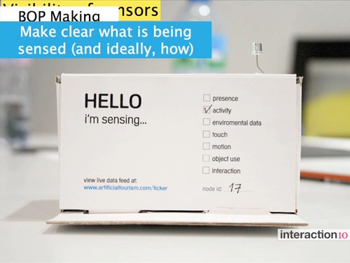
Courtesy of Dan Hill. Making clear what is being sensed. Extracted from Dan Hill’s IxDA talk on New Soft City.
Empirical observations
In a first case study in collaboration with the Mobility Service of the City of Barcelona, we first wanted to find out the correlation factor between the movements captured from the mobile device detections and the actual rhythm of the flow of pedestrians in the public space.
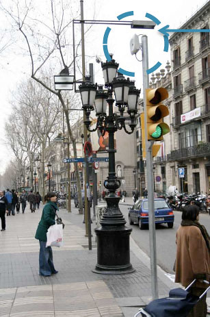
Bluetooth scanner deployed on traffic light at La Rambla
We retrieved a couple of months of records produced by 5 Bluetooth scanners, deployed by the Mobility Service of the city of Barcelona on light poles and traffic poles in the Barcelona city center in the Plaza Catalunya – Puerta del Angel – Rambla – Cathedral area. BitCarrier’s solution aggregated over 4 millions non-unique devices (about 1 million unique devices) into periods of 15 minutes, and we discarded the periods with less than 100 detected devices. The database provided a first understanding of the cyclical nature of passing Bluetooth traffic at the nodes and routes forming a connected graph of sensors.
The graph linking the observed areas is a fundamental concept of the analysis (similarities with Space Syntax “axial map” of the streets). This graph is analyzed according the weights and each node (i.e. aggregated substance of Bluetooth interactions) and route (e.g. average speed between two nodes), helping qualifying the space and its evolution over a period of time. Yet, the quality and representativeness of the data must be verified prior to any occupancy analysis.
Correlating Bluetooth interactions with actual physical activity
The Mobility Service of the City of Barcelona deployed one extra scanner in a metro station with turnstiles that aggregate by hours the number of entering passengers. Both metro and Bluetooth data suffer of noise generated by a) an amount of “wranglers” not paying their fare by jumping over turnstiles and b) the fluctuating range of the Bluetooth spectrum potentially interacting with devices of non-passengers. Nevertheless, with these imperfections taken into account it remains possible to determine the correlation factor between Bluetooth interactions and passengers movements. We applied the correlation for periods (hours) aggregating more than 200 detections of unique devices. The scattergram below correlating the device detection (horizontal axis) with the integration value of the metro station (vertical axis) reveals as large positive strength and direction of a linear relationship (+0.93). Note once again that no data or value on mobility is perfect. In this case, there is a certain bias in our approach because metro passengers represent a certain population that might be more in verse of carrying a Bluetooth-activated mobile phone than the general population. Similarly, other areas might reveal different correlation factors due to digital attractors. Nevertheless the large positive relationship we uncovered confirms that the actual physical activity conditions the activity on the Bluetooth spectrum.
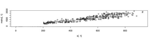
Correlation of device detections (horizontal axis) with the integration value of the metro station (vertical axis) reveals as large positive strength and direction of a linear relationship (+0.93).
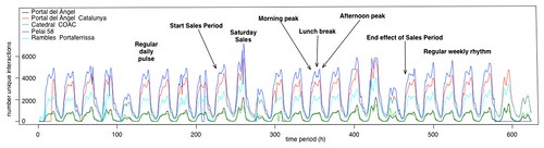
Measuring the ramification of an event
The empirical observations revealed the influence of the Winter Sales period over the general dynamic of the area we covered that hosts many shops. The Mobility Service of the City of Barcelona was particularly keen on obtaining indicators on the ramification of this phenomenon. Therefore, we compared the capture of absolute numbers of device detection of the average “eventless” period with the Winter Sale period, uncovering the areas that profited more of the Sales period than others. In a nutshell, the areas profiting the most from the increase of people are the Pelai area on Friday evening and Saturday afternoon, la Rambla on Saturday around noon and Puerta del Angel with the Cathedral area only on Saturday afternoon. The novelty of the approach is the ability to measure the impact of the event. For instance our analysis of Portal del Angel reveals an average absolute increase around 14% of activity on the Bluetooth spectrum over the Sales period. This type of observation over time can lead to the development of indicators of mobility, occupancy levels and usage of the space.
Defining indicators
At this stage, a pre-aggregation processing of the Bluetooth trails is necessary to further characterize the urban space. Therefore, we developed algorithms to extract pedestrian from vehicle movements and infer resident, transient, business, and tourist flows. These variables form time series that represent the temporal signature for each observed area and street (see for instance the application of eigenvector analysis on temporal signatures of a GSM network). When analyzed, these temporal signatures can help define indicators of the evolution of movements and presence of people. We developed a variety of indicators defining the streets of Barcelona based on:
- Walkability: considering the ratio of pedestrians and vehicles and a fluidity indicator. This observation is complementary to the walk score based on the topology and infrastructures Walk Score and Space Syntax’s Pedestrian Routemap that focus on spatial layout in shaping patterns of human behavior, with the support of traditional surveys.
- Accessibility: considering the main flows and speed to define level of access from any node (i.e. Bluetooth scanner) of connected graph (shallow and deep) from by the Bluetooth scanners.
- Permeability: level of protection of an area from the main areas, considering closeness and speed of flows. Inspired by “qualities” defined in Responsive Environment, A Manual for Designers.
- Attractiveness: as already explored in the New York City Waterfalls project with the application of comparative relative strength and centrality index of visitor traffic.
- Vitality: considering the constancy and high-level flows of both resident and transient activity. Inspired by Lynch in Good City Form and he definition of the five basic “performance dimension for the spatial form of cities”: vitality, sense, fit, access and control.
- Durability: constancy of the temporal signatures indicating the resistance to change or the maintenance of a current state.
Communicating, evaluating and planning with indicators
The first step of defining space management strategies is to gain an understanding of how people use and move through urban areas and then develop indicators to evaluate the strategies and their evolution. This practice necessitates a visual language through which interlocutors from different domains can communicate, evaluate, plan and make predictions about the resulting impacts.
Urban design and planning traditionally use visual ‘diagnostics’ for analyzing a situation and manipulate maps to communicate plans. Yet the representations generally map the – relatively durable – physical and functional layout of cities. In contrast, the activity patterns of crowds detected with wireless sensors are more dynamic. A visual language must prevent mismatches in trying to understand relations between the static and the dynamic. (see Jeroen van Schaick‘s paper Future Scenarios for the Relation between Advanced Tracking Research and Urban Design and Planning for a discussion on that topic). Nevertheless, the intuitive affiliation of practices dealing with the urban space to maps and diagnostic tools led us in prototyping dashboards to monitor and communicate the dynamic movements in the environment and their indicators.
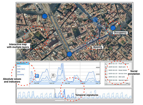
Fast-prototyped interactive dashboard for the Barcelona City Center, mixing areal and temporal views of absolute values and indicators, plus flags to annotate particular event.
Current applications
Good local indicators and knowledge on their rhythm can become operational material for multiple domains to determine and evaluate the appropriate strategies to space and mobility management. For instance, we have been perfecting a system to measure hyper-congestion situations and evaluate space management strategies. Our colleagues at BitCarrier collaborate with Centre for Innovation in Transport (CENIT) in Barcelona work on generating Origin-Destination matrices key to the modeling and prediction of traffic. Similarly, Arup and the Centre for Real-Time Information Networks (CRIN) at UTS have been investigating the Bluetooth wireless spectrum to detect transit activity in real-time, complementing current transit data that are not scalable and does not uncover individual ‘multi-modal’ trips (see Sensing the city, update one: our approach) Their project has priority of keeping the great promise of cities as enabler of both anonymity and community – current applications work with that balancing act, not against it.
Future: Bridging the applicability gap
We are imagining how a “data deluge” – with all manner of data continuously permeating the streetscape – can improve cities, their design and their policies. Yet, only a few researchers and practitioner have been really active on the field. Nevertheless appropriating Dan Hill’s words it seems clear that a shift to empirical observations and real-time data decision-making in the fields dedicated to the design, planning and management of space is fundamental, and not without complexities, but will surely happen. Our collaboration with BitCarrier certainly aims at shaping that future with clients/pioneers sharing the vision.
The challenges do not solely stand on technology and ethics. Our work is fundamentally multidisciplinary and the innovation based on the exploitation of empirical observations must still address mismatches between knowledge domains and practices. Particularly architecture and urban planning are not primarily about understanding a past or present situation. They specifically display possible and/or desirable futures of the layout of physical space (see Future Scenarios for the Relation between Advanced Tracking Research and Urban Design and Planning for a discussion on that topic). In contrast, the information our solutions provide display the actual pattern of movement either in the past or real-time. Our clients are helping us figure out how can current practices appropriate our alternative or additional method of observation and analysis. However, even in light of the accuracy and amounts of data, to many practitioners it is still not trivial to adopt new techniques and understand if theses information are really what they need. Bridging this applicability gap is a difficult task we like to accept!
Why do I blog this: Solidifying a rationale and grounding my discourse on current projects using Bluetooth. Now wearing the farmer’s hat. Planting seeds and weeding and hope for harvest.
Posted: March 17th, 2010 | No Comments »
The last article dispatched from my PhD thesis has been accepted for publication in the journal Pervasive and Mobile Computing. The slow academic process to diffuse research results – this study was performed in 2007-2008 – has at least the merit to force authors in looking back into their methods and procedures. Now in 2010, inspired by Nicolas’ Field Research for Design and others, I probably would perform the qualitative data collection and analysis differently. Nevertheless, I still believe this work delivers some relevant insights on people appropriation of location-based systems.
The co-evolution of taxi drivers and their in-car navigation systems (pre-copy-editing pdf)
Abstract. The recent market success of in-car navigation systems creates the opportunity to investigate the appropriation of location-aware systems outside laboratory settings. Through ethnographical lenses, we study how this technology changed the practice of a massive community of its early adopters, the taxi drivers of Barcelona (Spain) and, specifically, their exploitation of pervasive geoinformation. The results show co-evolution: taxi drivers adapt to their in-car navigation systems and adapt them to their needs; in particular, there are evidences of an alteration of the learning processes and of technology appropriation to reduce stress rather than to improve efficiency. We argue that these findings can inform the design of next generation location-based services.

The interplay between a sat-nav and a city guide. Barcelona, June 2008.
Why do I blog this: Last article of my PhD thesis to be accepted. In this study I particularly learned how to a) design a qualitative data collection procedure and b) analyze and interpret the notes, videos and photos.
Posted: March 6th, 2010 | No Comments »
Next Wednesday (March 10, 2010), will take place a seminar on Mapping Contemporary Cities at Laboral in Gijón, Spain. The event will gather practitioners active in hard urban realities, soft urban infrastructures and information visualization. Beyond cross-disciplinary pollination, the aim will be to develop innovative work in understanding, representing, mapping, communicating metropolitan areas that gather all the indicators of a city without featuring a dense urban fabric. It is particularly the case of the polycentric urban area in Central Asturias, Spain formed by three mid-size cities acting as one metropolis with its specific patterns of mobility, high car use, increase of express bus and train lines, dense information networks, and new attraction points as shopping centers or industrial land. Being able to channel the strategies of several urban entities into one metropolis is a major challenge for politicians, decisions-makers, infrastructure owner and service providers.
I was inspired by a talk of Antoine Picon (Towards a City of Events: Digital Media and Urbanity) and the extensive work of Fermín Rodríguez Gutiérrez on Ciudad Astur to setup and frame the event:
Mapping Contemporary Cities (en español):
Urban mapping is a mean to lead us to explore further what is happening today in the urban realm. In the Renaissance, many maps were about presenting the portrait of the city, its physiognomy, like a person, and its main monuments. Later, in the seventeenth and eighteenth centuries, maps were more and more often about urban geometry. In the nineteenth century, maps conveyed notions about new dimensions of the city like its networks (e.g. sewer maps, state of traffic). Nowadays, with the complexity of cities and their invisible soft infrastructures, even their centers have become hard to understand using the traditional means of cartography.
Simultaneously, digital media is changing the city as we experience it but also as we understand it. Tools and crawlers can now absorb new vast amount of data and represent it again through maps. While these tools help engineers, planners, geographers, decision makers, civil servants, inhabitants capture the city at a glance, they also make us aware of the limitation and imperfection of the transformation of the information. Does the digital bring us cities that are move visible and cognitively understandable? Can it help reveal cities such as Ciudad Astur with no visible urban homogeneity but strong invisible indicators of a metropolitan area?
To explore these questions, this seminar gathers practitioners active in the hard urban reality, digital cities and information visualization.
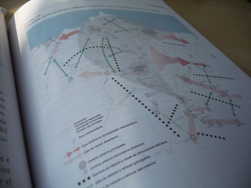
An effort of mapping “invisible cities”, here the work of CeCodet on Ciudad Astur in the book “El área metropolitana de Asturias. Ciudad Astur: el nacimiento de una estrella urbana en Europa“.
Thanks to LABoral Centro de Arte y Creación Industrial for generously supporting this event.
Posted: January 8th, 2010 | No Comments »
John Tolva wrote an short essay “Data: our second city” condensing a year of conferences and talks informed by IBM’s Smarter Cities perspective all with a Chicago bent. Certainly also inspired by the texts and talks of Dan Hill and Adam Greenfield, he starts with the observation of the data that now continuously permeates the streetscape (i.e. similar to my new urban actors slide) to propose discuss the near-future opportunities of their presence:
Visualization as to engage the dialogue: “our city planners and citizenry need to be at least as conversant with the language of information architecture as we are, at a basic level, about physical architecture. Call it an aesthetics of data. This is as much a matter of becoming aware of what’s happening around us, of figuring out the most elegant ways of making the unseen felt, of thinking of our urban spaces as I described the interactions at Michigan and Congress“. Our work in Florence is an example of the use of visualization to integrate citizen into the discussion.
Data to empower: “Our plan for a networked urbanism should seek above all to be maximally enfranchising, lowering barriers to commerce and community.”
For this to happen, John suggests that:
We must take up this mantle and be active participants in the design of this networked urbanism. We must make our voice heard. From educating our elected representatives about the opportunities before us, to encouraging our youth — who increasingly live in a world of data — to think critically about their role in the urban fabric, we must embrace this challenge with the same passion embodied in our historical tradition of remarkable plans for Chicago.
However, John could have further suggested that we will need current processes to integrating evaluation tools/techniques/methods/procedures to ensure that our digital infrastructure avoids the mistakes of our physical infrastructure. An urban environment will make the envy not just of building architects but of information architects.
In addition, any strategy should take into consideration the imperfection of the software infrastructure; the kind of “potholes in the urban Information landscape” John describes:
But fissures in a city’s data infrastructure are as consequential as potholes. They are structural failings of a city at the most basic level, in a way that a busted piece of street art would never be.
Think of cell phone outages — “dark zones” — as potholes in the urban information landscape. Or consider GPS brownouts, such as cause error in bus-tracking when the CTA enters the satellite-blocking skyscraper canyon of the Loop. But these examples are minor compared to the real issue before us: how do we proactively build a city of information that is inclusionary, robust but flexible, and reflective of a city’s unique character?
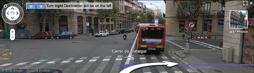
Turn right, … or not. A classic pothole in the urban information landscape
Why do I blog this: Further collecting thoughts for future talks and essays; as well as linking other people’s work with my endeavors. The necessity to educate elected representatives, decision makers, companies and citizens are part of ongoing projects at Lift lab. Beyond developing visualization and workshops to educate and open dialogue between the different stakeholders of the urban space, we develop tools that enable to evaluate urban strategies.
Posted: January 8th, 2010 | No Comments »
Jonathan Raper, who chaired yesterday’s London set for information revolution during which London’ mayor announced the city’s open data project (see London datastore) explained why policies towards information has evolved in the UK from Thatcher’s ‘user pays’ principle to the opening governmental agencies datastores due to recent ‘digital transition’, ‘mobile revolution’ and ‘open source movements’; and warns that a lot of work has to be achieved to make this promised future happen:
However, this is only the beginning of the process:
- we have to unwind some of the commercial partnerships government has in place to manage its information to ensure that it is released without conditions;
- we have to remove provisions like limitations on ‘derived data’ products when new opendata services want to use government data as a framework;
- we must look for ways to ensure that the innovations to be created are offered to all with full accessibility;
- we must ensure that the legitimate privacy expectations of the citizen are not compromised by information releases.
Why do I blog this: The conditions and limitations on ‘derived data’ products is often overlooked in open interface/data initiatives, and developers/analysts/entrepreneur must often act in grey areas. At what point are data derived enough to lose their open/public/free status?
Posted: January 6th, 2010 | No Comments »
Earlier last year, the FING, as part the the Villes 2.0 program, conducted a set of interviews on the development research in social and human sciences that study the relation between the information/communication technologies and the urban environment. Thierry Marcou and Sylvain Allemand asked french-speaking researchers in the domains of social sciences, urbansim, geography and information sciences (including myself) to reflect on the digital evolutions cities face; such as access and use of urban services, the approaches strategies and methods to understand the evolution and innovate with new urban services. The initial observation of their report entitled “La recherche urbaine à l’heure de la Ville 2.0“, highlight the necessity to consider the relation between ICTs and the urban environment beyond the infrastructures (e.g. politic to guarantee optimal coverage of a territory in high-speed Internet) and start to think about the implication in the urban context. In fact, these current strategies that aim at bringing infrastructure into the age of network culture still remain far from the goal of urban planning to arrange harmoniously people and activities in a territory (see Victory Gardens, or the Impact of the Financial Crisis on Architecture for some provoking thoughts).
A few concepts thoughts extracted from the report particularly caught my interest. Particularly the interview of geographer Jacques Levy who downplays the role of technologies to empower citizens:
“La ville n’est pas seulement gérée par les systèmes d’ingénierie, mais aussi par les habitants qui se rendent capables de maîtriser et de faire évoluer cet immense environnement qu’est une ville. Ils sont donc tous techniciens, en gérant des informations multiples sur les lieux ou en construisant des stratégies de mobilité”. Des citadins, rappelle Jacques Lévy, qui n’ont pas attendu l’internet pour devenir des acteurs, et par exemple, au travers de la civilité, « reconstruire la ville à chaque instant dans l’espace public ».
This notion of civility particularly important not to reduce the use of Internet technologies for radical ways to manage the urban (e.g. emerging urbanism), but also how they can contribute to the renewal of current models. For instant Levy discusses the necessity of decision makers to, from now on, deal with the “micro-arbitration” of citizens.
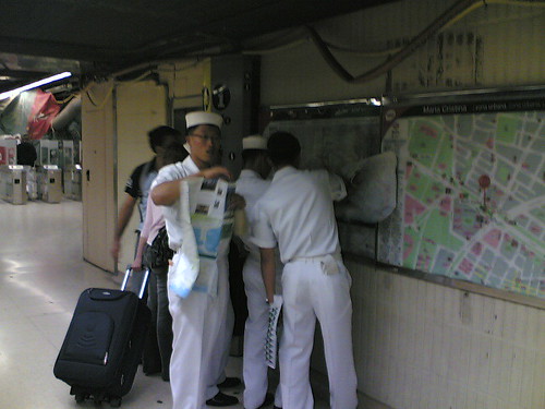
Sailors navigating the Barcelona subway system. They have not waited the Internet to become technicians, managing multiple spatial information and developing their mobility strategies.
My interview was conducted in early 2009, freshly out of my stay at MIT SENSEable City Lab. It highlights some of the contributions I try to make in the domain of research in urban informatics. Some of my thoughts have evolved since, but the core reminds intact. This is a good opportunity to recap what I believe are my main contributions:
Research contributions
Information/Communication/Location technologies, rather than have not dissolved the city; space is still predominant with altered experience (see CatchBob!) and appropriation with practices, ecosystem of artifacts and cultures as driving factors of co-evolution (see Taxi drivers) .
Implicit engagement, with citizens acting as sensors (see Tracing the Visitor’s eye) generating data as sources of new types of urban indicators (see NYC Waterfalls) to evaluate urban strategies.
Research approaches
The necessity of hybrid researchers: “Autrement dit à ces chercheurs et lieux de recherche et d’étude qu’on pourra qualifier d’« hybrides », au sens où ils procèdent à partir de recherche action, sur la base de partenariats public/privé, en développant des méthodologies entre recherche fondamentale et appliquée, voire entre sciences et arts.” [...] “Ce serait un chercheur qui ne craint pas de côtoyer les différents mondes (académique, élus, entreprise…) ni de pratiquer les langages des différents parties prenantes“. (see on hybrid forums and the kind of research I am).
Communication beyond a certain community as an integral part of the research process: “Au-delà d’une ouverture sur les autres disciplines et pratiques professionnelles, le chercheur idéal se préoccupe aussi de la manière dont il communique le fruit de son travail auprès des gens ordinaires. Communiquer au-delà de la communauté scientifique devrait faire partie intégrante de la démarche du chercheur en technologies urbaines“. (see Below the Tip of the Urban Data Iceberg and for instance Les Audiences dans la Ville and L’MIT di Boston Digitalizza la Vita Dei Turista a Firenze).
Human as a focal point at the intersection of technologies and urban spaces: “Aussi curieux que cela puisse être, le contexte urbain est encore peu concerné par les pratiques de co-conception que l’on observe dans le secteur de l’informatique et du numérique. Pour ma part, je ne conçois pas d’imaginer des dispositifs sans analyse de ses usages et usagers Ces intersections de pratiques permettent de définir un nouvelle approche qui prend en compte l’Homme dans l’intégration des technologies dans l’espace urbain“. (see post-occupancy evaluations).
Feed from provocation for instance through design fiction and artist works: “Oui, tout à fait. Les artistes en particulier jouent un rôle majeur, en amont des recherches académiques.”
Feed from urban scouting (see sliding friction)
Research methods
Mixed research and use of probes: “A objet d’études original, moyens spécifiques : nous allons jusqu’à concevoir nous-mêmes des outils particuliers, comme ces « mouchards » placés dans les téléphones pour collecter des données quantitatives qui supportent les observations sur le terrain“. (see CatchBob! and Flight detection)
Rapid prototyping to create potent provocative ideas and feed larger investigation: “Au sens du mot anglais « hack», qui veut dire « détourner », sous entendu pour trouver des portes auxquelles on ne pense pas, en n’hésitant pas à tester des solutions” (see Velib / Bicing).
Visualization as a starting point, not an end: “Bricoler, cela peut consister, par exemple, à mettre des données sur des cartes et noter des comportements émergents, pour établir des corrélations ou dégager une dynamique spatiotemporelle qui aide à une première compréhension des données. Elle ne parlera pas forcément au commun des mortels, mais au moins permettra-t-elle de nourrir l’imaginaire du chercheur, d’amorcer une discussion au sein de son équipe. Les réactions que cela suscite sont souvent instructives“. (see the World’s Eyes)
Why do I blog this: Gathering thoughts for upcoming essays and talks.
FING has been leading an active investigation in France, acting both as a think-tank and make-tank in the domain of digital cities. I am not aware of any initiatives at that scale in other countries. Chapeau! They investigate and consult beyond academia, relying on other observer of the digitization of urban, more of the hybrid researchers type. Indeed they are often as very capable to capture, treat the issues and communicate on the domain. For instance, marine biologist and entrepreneur Juan Freire offers a unique sensitivity translating the experience in his domain to the context of the city (see Urbanismo emergente, pro-común y tecnología).