Posted: August 27th, 2009 | No Comments »

My paper Quantifying urban attractiveness from the distribution and density of digital footprints co-authored with Andrea Vacarri, Alexandre Gerber, Assaf Biderman and Carlo Ratti has been published in the Volume 4 (pp. 175-200) of the International Journal of Spatial Data Infrastructures Research as part of a special issues on Next Generation Digital Earth. The Journal is published free of charge and adheres to the Open Archives Initiative, which aims to facilitate the dissemination of electronic content.
Abstract. In the past, sensors networks in cities have been limited to fixed sensors, embedded in particular locations, under centralised control. Today, new applications can leverage wireless devices and use them as sensors to create aggregated information. In this paper, we show that the emerging patterns unveiled through the analysis of large sets of aggregated digital footprints can provide novel insights into how people experience the city and into some of the drivers behind these emerging patterns. We particularly explore the capacity to quantify the evolution of the attractiveness of urban space with a case study of in the area of the New York City Waterfalls, a public art project of four man-made waterfalls rising from the New York Harbor. Methods to study the impact of an event of this nature are traditionally based on the collection of static information such as surveys and ticket-based people counts, which allow to generate estimates about visitors’ presence in specific areas over time. In contrast, our contribution makes use of the dynamic data that visitors generate, such as the density and distribution of aggregate phone calls and photos taken in different areas of interest and over time. Our analysis provides novel ways to quantify the impact of a public event on the distribution of visitors and on the evolution of the attractiveness of the points of interest in proximity. This information has potential uses for local authorities, researchers, as well as service providers such as mobile network operators.
Why do I blog this: Last version of the paper that presents our study of the evolution of the attractiveness of the New York City waterfront. It was improved based on the reviews that I documented in Accepted Paper: Quantifying urban attractiveness from the distribution and density of digital footprints. This work has also been vulgarized in: NYC Waterfalls: How Real-Time Cellphone Data Can Impact Local Economies.
Posted: August 25th, 2009 | No Comments »
The book Digital Cityscapes: Merging Digital and Urban Playspaces has been released recently. The description goes as follows:
The convergence of smartphones, GPS, the Internet, and social networks has given rise to a playful, educational, and social media known as location-based and hybrid reality games. The essays in this book investigate this new phenomenon and provide a broad overview of the emerging field of location-aware mobile games, highlighting critical, social scientific, and design approaches to these types of games, and drawing attention to the social and cultural implications of mobile technologies in contemporary society. With a comprehensive approach that includes theory, design, and education, this edited volume is one of the first scholarly works to engage the emerging area of multi-user location-based mobile games and hybrid reality games.
It features a chapter I co-authored with Nicolas discussing the issues for the design of Location-Based Games based on our experience with CatchBob!. We give an overview of the three main design issues our results supported: the role played by physical features, the importance of the technological infrastructure and finally the user experience of location-awareness of others.

Why do I blog this: After Space Time Play, it is clear that studying ubiquitous games has consequences for many other areas of contemporary research and daily experience.
Posted: August 24th, 2009 | No Comments »
A couple of recent workshops on the design of urban spaces and the products and services that will populate them in the near future:
Urban Life and Urban Space Qualities – New Knowledge, Methods and Knowledge Needs
The interest in the urban space and life has become stronger in the last few years. The extent of events in the streets and open spaces of the cities is increasing. The acknowledgement of the importance of good urban spaces has improved, and the number of urban spaces projects is huge. But who actually uses the urban spaces, which urban spaces are used? And how do they use them? What characterizes the good urban space? And how and by who is it evaluated? How is a better co-operation between urban space researchers, decision makers and users established? Is it the right urban spaces which receive investments? How can research optimize the basis for decisions?
Informing the design of the future urban landscape
The workshop will seek to address questions such as: What form will the information landscape take? How will people adapt their behaviours and indeed how will the nature of the urban landscape alter as increased amounts of information is overlaid on the physical environment? What new products and services will be available given the increase of targeted information aimed at specific communities and interest groups? Will this result in an increase in segmentation and fragmentation associated with the urban experience leading to the possibility of the creation of multiple experiences of the same physical space. What will inform the visual aesthetic of the future information landscape?
Street Computing workshop at OZCHI 2009
The increasing availability of an urban computing infrastructure has lead to new and exciting ways inhabitants can interact with their city. This includes interaction with a wide range of services (e.g. public transport, public services), conceptual representations of the city (e.g. local weather and traffic conditions), the availability of a variety of shared and personal displays (e.g. public, ambient, mobile) and the use of different interaction modes (e.g. tangible, gesture-based, token-based).
This workshop solicits papers that address the above themes in some way. We encourage researchers to submit work that deals with challenges and possibilities that the availability of urban computing infrastructure such as sensors and middleware for sensor networks pose. This includes new and innovative ways of interacting with and within urban environments; user experience design and participatory design approaches for urban environments; social aspects of urban computing; and other related areas.
Why do I blog this: Emerging events that, from different domains, discuss 1. importance of good urban services and spaces (what is a good urban environment) 2. who evaluates then and 3. what is the overall design process (participatory approach)?
Posted: August 22nd, 2009 | No Comments »
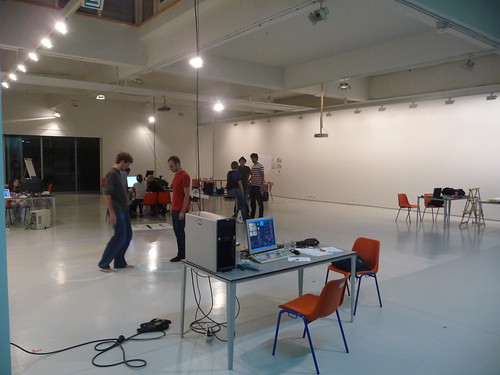
In the talk “Considerations on the recorded, quantified, communicated and apprised self” given at the workshop Information Kinetics: Egoviz, I present my experiences in working with the increasing amount of stored (and circulating) information about people, and their local environments. I intended to draw a few considerations to provoke and encourage the participants who have been developing some pretty exciting projects that explored the visualisation of the relationship between the individual and the environment. With a few examples, I highlighted the fact that current visualizations are used to engage the discussions rather than solving issues. Going beyond revealing the invisible is the next step that must include imperfection as an ingredient embedded in the solution. This imperfect mirror to reality challenges the rhetoric that describes the development of information kinetics as element of an emerging panopticon. Instead, I discussed the notion of the oligopticons that are “partially intelligent, temporarily competent and locally complete. The slides with notes are online.
Engaged with the near future of egooviz at Arteleku
Why do I blog this: It is always extremely stimulating to confront my work in an art center. I was particularly surprised by the maturity of the rhetoric participants use to describe their work. Some non-technologists now master Processing and its capabilities. Those are tangible signs of the emergence of groups of data scientists/artists with multidisciplinary practises and overlapping roles. Thanks to Kepa for the inviation!
Posted: August 12th, 2009 | No Comments »
In the concluding chapter of my dissertation, I discuss the value of multiple points of view to understand an urban environment and people practices. My work shows that the increasing availability of soft infrastructure improves the collection of longitudinal observations and the emergence of evidences from the statistical relations with variables (e.g. What is the effect of new physical layout on movement?).
However, my work also suggests that there is a big assumption in seeing the world as consisting of bits of data that can be processed into information that then will naturally yield some value to people (see data-driven urbanism). For instance, in my study of the Manhattan waterfront, the data stays blind to inform on the ways people used the space. It is evident that the understanding of a city goes beyond logging machine states and events. Therefore, the “data-scientist” fascination of the massive amount of data cities produces in “real-time”, should not discard the other points of view necessary to understand the multiple uses of the city and its space over time. For instance, the legacy of William H. Whyte and his careful observation of use and appropriation of the space (watch for instance the intro of the The Social Life of Small Urban Spaces video) attests the invaluable virtue of qualitative analysis. Other points of views scrutiny the time-space relationships in the form of “chronotopic studies” (e.g. Etude Chronotopique de Pigalle) valuable to practitioners such as the Bureau des temps in Paris that focuses on improving of the “rhythm” of the city.
More than ever, there seems to be a real opportunity to collocate these multiple points of view around a practice that mixes quantitative data analysis with qualitative observations employed by Whyte. This combination of observational techniques has been mainly explored to understand the use of mobile technologies. For instance Matthew Chalmers’ Sumgroup has been developing analysis tools mixing video recording, and system-based techniques that log the technologies in use (see Recording and Understanding Mobile People and Mobile Technology and Andy Crabtree’s Digital Records for e-Social Science). Besides the challenge of synchronizing the points of view, there are numerous (physical, political, technological, ethical) constrains that prevent from capturing the proper angle from carefully chosen vantage points. One solution comes from the alternative, non-traditional, ways of seeing the world around us. Julian Bleecker’s latest Apparatus for Capturing Other Points of View is an example of new angles to observe and perhaps produce useful insights. Beyond the traditional “video annotations”, there are plenty of opportunities for the post-processing stages of the activity. Julian suggests some “explorations of ways in which individuals or small groups of people in movement could become their own producers of representations of what they do, in an aesthetic sense“. Other researchers look at video post-precessing to improve their city dynamics models object detection and space-time trajectory estimation (see Tracking Pedestrians).
What becomes intriguing with the couplings between the analytic data and the observed activities of people is the ability to superpose the top-down-city-as-a-system with the bottom-up-people-actions; in other words unveil how people appropriate, hack, desert the space according to its layout, design or regulations. The application of qualitative/quantitative, traditional/alternative points of view would mean a shift in the urban design and planning practices from the speculative predictions and accommodation to more factual observations and improvements addressing local needs. In the conclusion of my dissertation I explicit the interplay of the different points of view:
The qualitative analysis to inform the quantitative queries: This approach first focuses on people and their practices, without the assumption that something computational or data process is meant to fall out from that. This qualitative angle can then inform a quantitative analysis to generate more empirical evidences of a specific human behavior or pattern. A few approaches in that domain address this perspective. Williams et al (2008) for instance argue that our understanding of the city could benefit from a situated analysis of individual experiences within cities, rather than taking particular urban forms as a starting point for the study of urban experience.
The quantitative data mining to inform the qualitative enquiries: In that approach, the quantitative data help to reveal the emerging and abnormal behaviors, mainly raising questions. The qualitative angle then can help explaining phenomenon in situation. The qualitative approaches actually requests to ask the right questions to learn anything meaningful about a situation.
An example of the latter could have been applied to the context of the impact of the New York City Waterfalls (Chapter 6). We used digital footprints to reveal the variations in spatial presence and abnormal patterns of temporal presence over the course of a 2 years period. In addition to this quantitative analysis we could have performed qualitative observation on the detected areas to reveal how the attractiveness evolves (e.g. Do people stay longer?).
This fosters the need for research and practitioners to develop a coherent understanding of the traces of the activity: both qualitative (e.g. audio and video recordings of action and interviews) and quantitative (e,g. logfiles). With significant data on actual use of the space, we can perform new types of “Post-Occupancy Evaluations” often overlooked in the practice of urban design and architecture (Brand, 1995).
Why do I blog this: For a current project, I am exploring the multiple points of view to capture city dynamics. It starts by including citizen to elicit and describe the local dynamics and needs to feed the data analysis process of their city. They can create their own point of view with the ability to observe and capture their environment. This potential to capture, observe and replay the city echoes very well with the recent interest of some architects, urban planners and designers in unconventional data sources (e.g. beyond traditional surveys). But how does it integrate into the current practice? Is there a spot for some vernacularism? How can urban scouts and urban safaris communicate with practitioners and decision makers? See also Marcus Foth who uses participation and visualisation features to assist narrative generation and make transparent how users understand and interpret proposed urban designs (The Second Life of urban planning? Using NeoGeography tools for community engagement).
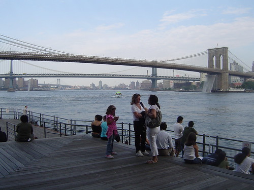
My study of the NYC Waterfalls (see Digital footprints as evidences of urban attractiveness) originally aimed at augmenting the data mining with situational observations at the key vantage points. The evolution of the attractiveness of a space also relates to the behaviors of visitors of the spaces. For instance the evolution of the types of groups visiting or What do they do when then stay?
Posted: August 9th, 2009 | 1 Comment »
Part of my PhD dissertation is now online. I still keep Chapter 2 and 3 offline because a large part of their content is under review for publication in journals. The final chapter was certainly the most rewarding to write as I could finally sense the amount of work produced and discuss the perspectives of the overall contributions.
Rather than following a traditional PhD thesis format, my advisor and I decided to present my work with a multi-paper format. First because this format facilitates explaining the interplay of methodologies (conceptual, exploratory, qualitative, design science) I employed in my work. Indeed, I believe relying on several journal papers rather than on a very integrated monolith helps in disseminating the knowledge that links several research communities. Second, the recommendation and comments from the article reviewers helped me increase the maturity of my work during the PhD. Therefore, the thesis defense ended up being just a formality, since a good part of my work had been peer-reviewed and published. Finally, it spared me an extra 6 months of building an “artificial” theoretical model, potentially generating a 300 pages document, that I do not believe would have added any value to my contributions. One might argue that the dissertation needs a more comprehensive litterature review. In fact my Master’s thesis Towards reducing the social-technical gap in location-aware computing plays that role and I found wiser to reference it rather than remastering it.
Now, all of my published work is available for download (some papers are in pre-editing version) and I have uploaded the bibtex file storing the 409 references I collected along the path to the PhD degree.
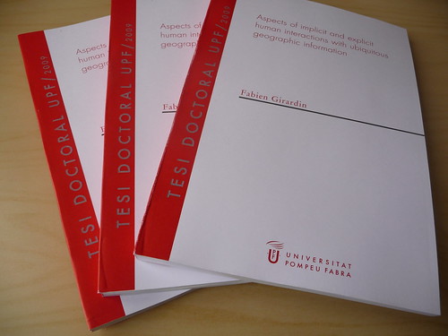
Paper versions of the dissertation, submitted in May.
Posted: August 6th, 2009 | No Comments »
Last week, a bad flu prevented me from attending the International Citizen Cartography meeting and presenting some of my latest work. With the presence of many people involved in activist mapping and DYI geopolitics projects, I had planned to start from Michael Goodchild’s notion of Volunteered Geographic Information (VGI) on the emergence of geographic data provided voluntarily by individuals, to discuss the greater presence of unvoluntarily generated geographic data. In the talk “Not So Volunteered Geographic Information“, I present my method to analysis these new kinds of citizen generated data, and use my work to discuss the induced opportunities, limitations and concerns. Since, I could not present on stage, I have intended to fill out the slides with extensive notes (slides with notes).

A process to generate value from digital footprints
Thanks to Pablo de Soto for his invitation.
Why do I blog this: In this talk, I intend to link the work produced in my PhD thesis with my current endeavors at Lift lab.
Posted: August 5th, 2009 | 3 Comments »
The completion of a PhD studies did not mark an end, but the start for a future to perfect. It is a milestone to judge what has been done and contemplate future paths. My thesis jury took care of the former and I will discuss the latter here: What kind of researcher these last 3.5 years have made me and how to proceed next?
What I have learned along the journey?
The path to the PhD taught me how to perform scientific research, with wide spectrum of methods starting from the experimental psychology I saw applied at EPFL, the mixed methods Nicolas employed to study mutual location-awareness and helped me dig to trigger concepts around my observations of spatial uncertainty. With the limitation of quantitative methods to study the messiness of the “real-world”, I embraced the value of qualitative observations to collect evidences and factual knowledge translatable into design knowledge. These description-driven (what is) results allowed me to enter a more prescription-driven (what can be) type of design science research method, closer to my engineering roots, with the generation of design knowledge in the forms of object-design, realization-design and process-design. Working with architects and designers at MIT taught me other approaches to build knowledge from multidisciplinary research (use of sketches, fast-prototyping, urban demos).
Members of my thesis jury questioned the applications of the multiple approaches that challenged the comprehensive and integrated theorization of the work. Indeed, the thesis could have been driven by a holistic theoretical perspective. However, I favored a pragmatic approach, discarding the production of any global theoretical framework that I regularly see artificially produced to complete a PhD thesis work. In fact, as agreed by the jury, my application of multiple approaches has a virtue in regards to its evolving approach to theory. It stresses the value of the interplay of methods to define the phenomena, then observe them and then control them (with design). Yet, the argumentation, clarification and defense of mixed-research methods is still necessary in academia. The constant discussion on the epistemological relevance of some research methods create enclosures within academia that do not provide a fertile ground on the way I conduct my research. It creates an overhead to communicate my work and make it prone to random rejections from an anonymous “quanti-centric”, “quali-only” or “design-is-not-a-science” peer. I notice that this lottery does not fit with my exploration of research processes that do not solely include scientists, as expressed by Bruno Latour in the World Wide Lab: “A crucial part of doing science is formulating the questions to be solved; it’s clear that scientists are no longer alone in this endeavor“.
With a few published journal papers, I have learned to master scientific communication (in english) with its rigorous formats and rules, but also its story telling tricks to capture the reader’s attention. Nevertheless, the overall knowledge dissemination process of academia makes me wonder about its relevance beyond its laboratories. As Julian puts it in Where to Next Design:
“The question of relevance also comes to mind with regard to academia, which was arguably the one thing you might guess I was preparing for. I mean, why else get a PhD in an area of inquiry that’s as close to Philosophy and Critical Theory as anything. I’m not hating too hard, but there are challenges ahead for academia if it wants to participate in the idea/knowlege/insight/culture circulation networks beyond the greenways of its campuses. There’s the insularity of its publishing practices. Who really reads the swirl of endlessly regurgitated write-ups that sluice through the ACM and Springer-Verlag presses every year. They’re locked away behind password protected and over-priced journals, have citation practices that have no qualms with incest and, let’s face it, peer-review? P’lease.”
Besides my many publications, the outcome of my research drew more attention and challenging feedback from hybrid forums than my academic communities. It might be the direct consequences on 1) my application of multiple approaches that do not fit to any precise research community enclosure 2) the insular nature of academia in the knowledge dissemination. In consequence, the venues to communicate and exchange have naturally become these hybrid forums, that bring these feelings of being in the belly of the beast instead being inclosed in some research community, with its limited access to scientific outcomes with an old publication model.
Finally, along the journey to the PhD, I have further developed other skills such as problem formulation, data exploration and interpretation and evaluating other people’s work. The latter was new in respect to my engineering background that did not prepare me in looking upstream. I have reinforced the skills and qualities from engineering such as the definition of a problem relevance and the application of rigor. (see also Anne Galloway’s What we learn list)
My terms to frame research
This PhD further alimented the wish to follow my curiosities rather than the clear career path academia would propose (see Julian’s curiosity rather than career). My thesis jury valued the exploratory aspect of my work with “highly innovative” and “high level of originality” remarks. In contrast, they noticed that my explorations created a “lack of an integrated literature review on the topic under investigation“. I wish to continue creating and argument the utility of “innovative” rather than “integrated” aspects of research. This path implies the development and appropriation of epistemologies, methodologies and purposes. In practical terms, it means leading research projects that call for new:
- Processes that, for instance, involve non-scientists (citizens) for question formulation, data collection and solution creation.
- Tools for sensor data mining, urban data analysis and analysis result communication. I will need to further develop my expertise in statistics and spatial analysis, participating to the Rise of the Data Scientist.
- Idea generation and solution creation; calling back my engineering skills to once again build for other rather than myself unlike I have been selfishly doing to support my research (see All jokes aside, engineers are practically creative).
- Upstream observations, looking into what research communities are contemplating for the near-future, trying to tease out some of the more absurd assumptions, naive projections and hidden agendas (see Interview with Mark Shepard: ‘critical design’, architecture, urbanism and location based media).
- Downstream observations, that consider implications of the integrations and appropriation of technologies, their context, applying for instance urban scouting practices (see Sliding Friction and 3 pieces about ethnography and design).
Next step
The hybrid place to perform research on these terms does not necessarily exist yet. We are creating it. More on that soon.
An engineer/researcher on the move