Mapping Contemporary Cities at Laboral
Posted: March 6th, 2010 | No Comments »Next Wednesday (March 10, 2010), will take place a seminar on Mapping Contemporary Cities at Laboral in Gijón, Spain. The event will gather practitioners active in hard urban realities, soft urban infrastructures and information visualization. Beyond cross-disciplinary pollination, the aim will be to develop innovative work in understanding, representing, mapping, communicating metropolitan areas that gather all the indicators of a city without featuring a dense urban fabric. It is particularly the case of the polycentric urban area in Central Asturias, Spain formed by three mid-size cities acting as one metropolis with its specific patterns of mobility, high car use, increase of express bus and train lines, dense information networks, and new attraction points as shopping centers or industrial land. Being able to channel the strategies of several urban entities into one metropolis is a major challenge for politicians, decisions-makers, infrastructure owner and service providers.
I was inspired by a talk of Antoine Picon (Towards a City of Events: Digital Media and Urbanity) and the extensive work of Fermín Rodríguez Gutiérrez on Ciudad Astur to setup and frame the event:
Mapping Contemporary Cities (en español):
Urban mapping is a mean to lead us to explore further what is happening today in the urban realm. In the Renaissance, many maps were about presenting the portrait of the city, its physiognomy, like a person, and its main monuments. Later, in the seventeenth and eighteenth centuries, maps were more and more often about urban geometry. In the nineteenth century, maps conveyed notions about new dimensions of the city like its networks (e.g. sewer maps, state of traffic). Nowadays, with the complexity of cities and their invisible soft infrastructures, even their centers have become hard to understand using the traditional means of cartography.Simultaneously, digital media is changing the city as we experience it but also as we understand it. Tools and crawlers can now absorb new vast amount of data and represent it again through maps. While these tools help engineers, planners, geographers, decision makers, civil servants, inhabitants capture the city at a glance, they also make us aware of the limitation and imperfection of the transformation of the information. Does the digital bring us cities that are move visible and cognitively understandable? Can it help reveal cities such as Ciudad Astur with no visible urban homogeneity but strong invisible indicators of a metropolitan area?
To explore these questions, this seminar gathers practitioners active in the hard urban reality, digital cities and information visualization.
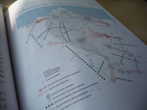
An effort of mapping “invisible cities”, here the work of CeCodet on Ciudad Astur in the book “El área metropolitana de Asturias. Ciudad Astur: el nacimiento de una estrella urbana en Europa“.
Thanks to LABoral Centro de Arte y Creación Industrial for generously supporting this event.