Posted: January 30th, 2009 | No Comments »
The responsive city seminars are part of the key moments of my stay at MIT for their ability to attract key experts and open participation. This semester they take a slightly more formal spin to become MIT Survey Seminar on Urban Innovations with, as last year, live case studies through talks by invited practitioners as well as surveys of relevant innovation by guest academics. This edition will focus on six themes of emergent urban innovation:
1. New Model for Transportation: How can city design, new vehicle concepts, and technology enable more responsive personal and mass transportation? Guest speaker: William J. Mitchell (Media Lab)
2. Digital Cities: How can personal technology, sensing, urban-scale media, and just-in-time information foster community, sustainability, and a better life-balance? Guest speaker: Dennis Frenchman (MIT Department of Urban Studies and Planning)
3. Live-Work: How can the city plan, architecture, transportation systems, technology, and services support a changing pattern of 24-hour distributed work, virtual offices, livework environments, etc.? Guest speaker: Michael Joroff (MIT Architecture)
4. Distributed/Centralized Energy: How can we design for both distributed and centralized energy? How can heating, cooling, and electrical loads be dramatically reduced through design innovation and technology? Guest speaker: Stephen Connors (MIT Energy Lab)
5. Sustainability, Health, Psychology and “Right to Light”: How can strategies for zoning, massing, density, architecture, and technology improve quality of life? Can every place of living have direct, unblocked sunlight, and views to nature? Guest speaker: Eran Ben-Joseph (MIT Department of Urban Studies and Planning)
6. New Model for Building Design, Fabrication, and Technology Integration: How can mass-customization, disentangled systems, off-site fabrication, and information technology enable agile, adaptable, high-performance, responsive housing? Guest speaker: Jarmo Suominen (Aalto University, Helsinki)
Posted: January 29th, 2009 | No Comments »
Over the holidays, David Lu produced some new visualizations for our World’s Eyes project featured in the Tourism: Spaces of Fiction exhibit at the Disseny Hub Barcelona. It includes for instance a new look on Barcelona through the eyes and of Britons. David kept track of the messy, organic trajectory delineated by mistakes and occasional success that led to these results. Some of his sketches could have been easily exhibited as well. These sketches follow a messy, organic trajectory delineated by mistakes and occasional success, mainly due to me being in Europe and him on the East Coast (in a classic senseable fashion). Data mining maestro Andrea Vaccari also contributed to the development of this work.


Relation to my thesis: Follow-up of the first iteration. This work is of great use to communicate my work outside of the academia.
Posted: January 28th, 2009 | No Comments »
James Rojas will give a talk on Design Based Urban Planning: A new method for community engagement workshop at MIT next Monday.

Relation to my thesis: user-centered design of the built environment: Communities engaged in influencing urban planning.
Posted: January 25th, 2009 | No Comments »
IFTF’s Anthony Townsend wrote an article that takes the New York City Waterfalls as context and the study I led on the evolution of the attractiveness of the waterfront as example of locative media, combined with the social media outlets of the web as enablers of public participation in public art (also see “Editer l’espace public” in Chronos).
Augmenting Public Space and Authoring Public Art: The Role of Locative Media (web – pdf)
Abstract: Locative media remain a useful frame for understanding how collaborative sensing will broadly empower groups to author alternative narratives of urban public space. The case of Olafur Eliasson’s New York City Waterfalls is used to describe this process in the context of a recent large public art work.
Anthony has some provoking thoughts that go right up to my alley in considering locative media provide a solid basis for investigating the larger implications of collaborative sensing and sensemaking. The example of the Waterfalls indicate that, in the future, artists will need to rethink how they engage the public as co-producers of public art and public. It implies the development of techniques and observations from both on passive activity sensing and pools of user-generated data (or as Anthony would say “the interplay between top-down systems of command and control versus bottom-up systems for collective action“). I would argue that this example with public art could extended to any kind of practice that touches the public spaces.
Relation to my thesis: “locative media will also extend our awareness of the urban condition” and “the next step of urban computing will be the development of platforms for making sense of these pools of user-generated data, and visualizing them in place.”
Posted: January 24th, 2009 | No Comments »
I was in Barcelona this week to present an extensive overview of my research work in the domain of people-centric sensing at the weekly 1-hour seminar of the local Yahoo! Research lab.
People-centric sensing in the city of the near future (slides)
Abstract. Technological advances in sensing, computation, storage, and communications is turning people as sensors of their own environment. Indeed, the increasing deployment of wireless and mobile devices produce new types of dynamic urban data that people generate by passively and actively interacting with these ubiquitous technologies. In this talk, I will illustrate through a few examples how the analysis and visualization of these data gives the ability to show previously invisible urban dynamics resulting in opportunities to inform the urban design, planning and management processes. Moreover, the increasing integration of these technologies into the fabrics of our lives could create more responsive cities in which authorities, service providers and citizens can monitor urban processes and react to events in real-time. Finally, I will ponder these opportunities by highlighting the complex socio-technical assemblage that challenges researchers and practitioners in designing the integration of these new dynamic urban information into people’s daily life.
Thanks to Ricardo Baeza-Yates for the invitation
Posted: January 14th, 2009 | No Comments »
Last week I was in Paris for the closing event of the Villes 2.0 program that gathered experts and practitioners on the “digitization” of the city and its novel open and participatory practices. Adam Greenfield sat the stage for the event with his opus “The Long Here, the Big Now, and other tales of the networked city” (video from Visualizar) that pleased me with some new considerations on the implication of this new urban reality on the practices of architects and urban planners. In other words, how can we develop “villes” (cities) 2.0 for us, humans 1.0? My contribution (slides) took place around this notion of “villes 2.0″, a city with new urban actors named Google, wireless networks, but also a city fostering citizens contributions and bottom-up information (see La Ville 2.0 existe déjà, on l’a rencontrée). I described how through our implicit and explici interactions with these new urban actors, we generate data that, when aggregated over space and time, bring novel perspectives (e.g. in real-time, on dynamics of the city. Beyond the possibility to visualize these dynamics, often useful to open or support discussion in the urban area, I suggested with examples of my recent research works that these data can become sources of urban indicators, valuable to develop an urbanism based on evidences (in the sense of signs and indications), particularly promising to perform new types of post-occupency evaluations. I described these notions more extensivily at Visualizar in Madrid, last November (video of From Sentient to Responsive Cities). Other sessions, covered the current and new practices to innovate in the urban realm (see Aborder les questions urbaines par l’innovation) and how this innovation can take place with open access to the edition of the city (e.g. with open APIs), a shared control between private companies and citizens leading with a promotion of the appropriation instead of a stubborn approach of innovation (see La ville 2.0, plate-forme d’innovation ouverte).
Villes 2.0 is a unique program, mixing think-tank and do-tank approaches, with outcomes in the forms of 3 books: “La ville 2.0, complexe … et familière“, “Manifeste pour une mobilité libre et durable” and “La ville 2.0, plate-forme d’innovation ouverte” supported by the exploration of the theories through several urban demos such as a Citywall, a real-time control system, and CityPulse as well as prototypes (see the flickrset).
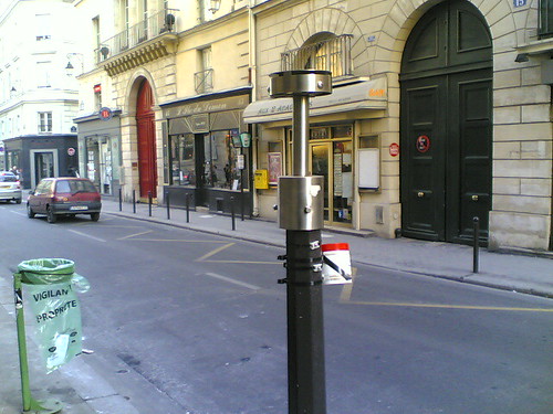
Within the Ville 2.0, the contemporary “Rue” 1.0 in Paris, governed by anti-terror measures and sustainable development. Here a sensor of some sort next to the vigipirate-promoted transparent trash bags sporting the slogan “viligance” and “cleanliness”.
Relation to my thesis: Testing my research outside of the academic arena. Interestingly, several urban/human geographers approached me after the session, interested on the potentials of my work to support their traditional approaches.
Many thanks to Thierry Marcou, Fabien Eychenne and Daniel Kaplan for the invitation!
Posted: January 12th, 2009 | No Comments »
As a follow-up of the work developed over the summer on the attractiveness of the NYC waterfront, the paper “Towards estimating the presence of visitors from the aggregate mobile phone network activity they generate” has been accepted for submission to the 11th International Conference on Computers in Urban Planning and Urban Management (CUPUM) that will take place in Hong Kong on June 16-18, 2009.
Relation to my thesis: The acceptance helps solidifying the legitimacy of my work on digital footprints. I plan 3 more paper submissions before finishing my thesis.
Posted: January 12th, 2009 | No Comments »
I will present the work and concepts developed with David Lu for the World’s Eyes visualizations at the GeoViz 3-days workshop on the “Contribution of Geovisualization to the concept of the Digital City“. The long abstract of “Exploration and analysis of digital footprints through interactive visualization” goes as follows:
In recent years, the large deployment of pervasive technologies in cities has led to a massive increase in the volume of records of where people have been and when they were there. With the ubiquity of mobile and wireless devices, the logs produced become anchored to the physical space with a geographical reference. The emergence of these digital footprints is expected to have significant impact on social sciences and urban studies with this novel access to a massive quantity of quantitative data. Indeed, pioneer works have demonstrated that their accumulation can uncover social behaviros and the spatio‐temporal interactions between people and places. In practice, the visualization and analysis of these urban data could deliver value added information in the different domains touching city management such as urbanism, environmentalism or tourism. For instance the visualization of the density of cellular network activity in a city can help traffic engineers improve public transport provisions in populated areas of a city at peak hours.
However, the dynamic nature of digital footprints and their fluctuating spatial and temporal resolution poses new challenges. Indeed these urban data come from cheap sources and infrastructures not deployed to sense the activities of a city. Therefore it is nececissary to assess the quality of the data through calibration with data collected with more traditional means (e.g. surveys, census data). These shortcoming greatly impair the use of these kind of information for city management and decision making in the near future. However, their visualization are already great tools to communicate with anectodes and evidences uncovered from exploration of this new types of data.
Our specific solution maps digital footprints visitors of a city leave behind them (Figure 1). The analysis of this traces allow to get a perspective on the density and flows of visitors and as a result compare the attractiveness of points of interests (Figure 2). Coordinated visualizations are integrated within individual probe interfaces, which depict the local data in user‐defined regions‐of‐interest. These probes empower users with the ability to observe, coordinate, and compare data over space and time and across multiple local regions. We have been developing this tool not only to interact with these digital footprings, but also to communicate explorations and findings. The visualization and the interaction also serve multiple different actors of the city such as the researchers, to interests groups, practitioners and politicians, to agree and disagree on how to interpret data and contribute contextual knowledge that deepens understanding.
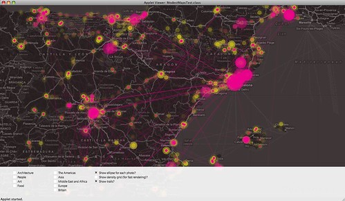
Figure 1. Interactive tool that visualize the density and movements of locals (yellow) and visitors (in pink) from the georeferenced photos taken in Spain and shared shared online.

Figure 2. Interactive tool that visualize the density and movements of photographers visiting Barcelona and sharing their photos online. Yellow glows shows the most attractive points of interest.