Posted: October 31st, 2008 | 1 Comment »
A few thoughts on the state of research in urban informatics sketched from here and there…
With a few workshops (e.g. Digital Cities, UrbanSense, Real-time Cities), loosly-related conferences (e.g. CUPUM, ), books (e.g. Handbook of Research on Urban Informatics, journal special issues (e.g. IEEE Computer, IEEE Pervasive Computing), dispersed research groups (Darthmouth College Sensor Networks Group, MIT SENSEable City Lab and Smart Cities, CMU Living Environments Lab, UCL’s VR Centre for the Built Environment and CASA) extensive blog post (e.g. Julian Bleecker, Karen Martin, Nicolas Nova; Anne Galloway’s blog a research tool) and courses taught at a graduate level (MIT’s ambient informatics, NYU’s urban informatics), urban informatics is not a research field but rather a set of intersecting practices and broader disciplines swirling about those practices. It is still ill-defined and at its infency with a lack of paradigm. I have always presented this intersection with three main tendencies: understanding urban dynamics, understanding the integration of ubiquitous technologies in urban life and designing technologies for people in the city. Others defined it as “the integration of computing, sensing, and actuation technologies in everyday urban settings and lifestyles“ (Kindberg et al., 2007) or “the collection, classification, storage, retrieval, and dissemination of recorded knowledge of, relating to, characteristic of, or constituting a city” (Foth, 2008). To my view, it involves the research on 4 layers:
1. Urban data gathering (What can be sensed?)
2. Urban data analysis (What can we do with what is quantitativly sensed and qualitativly observed?)
3. Information visualization (What can we communicate?)
4. Designing technologies and services for the city (How to design to improve?)
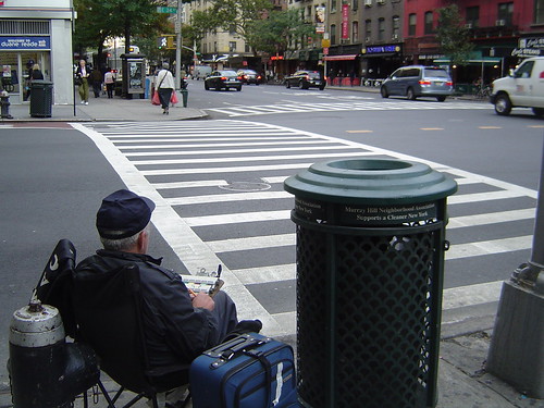
A urban informatics blue collar counting traffic of trucks, cars and bicycle at a random crossroad in a random gridiron plan city.
A majority of research done one or many of these layers has been driven by an utilitarist perspective that models a city as a system and that aims at improving its efficiency. The background of work in that domain partially explain the lack of consideration of human and social realities. Not to blame the, but computer and information scientists, engineers, architects, and urban designers are no necessearly trained in assessing the implications of their interventions. Only recently the technodeterministic approach has been challenged (e.g. in Urban Computing and its Discontents) through the influence of designers (e.g. Adam Greenfield and Dan Hill), social scientists (Anne Galloway, Bruno Latour), historian (e.g. Antoine Picon) and geographers (e.g. Phil Hubbard, Mike Crang and Stephen Graham). Their influence generates the emergence of a new language that computer scientists integrate in their work forging transdisciplinarity skills (highlighted my report of the Real-time City Round Table). In consequence, it is noticeable that now social considerations go beyond privacy issues and touch the domains of the impact of the research (e.g. positive change of practices) and the design for its appropriation (how to integrated into citizen daily life or a city administrative decision process). Nevertheless, research in urban informatics is still at an exploring phase that builds “telescopes” and “microscopes” that paint the city. It will need converging teams and languages to build a field and a science to study “what we see” and help generate theories and a body of knowledge.
Relation to my thesis: forming some thoughts on the context of my research that I can extend in my dissertation.
Posted: October 25th, 2008 | 6 Comments »
The methods and tools I have developed at the MIT SENSEable City Lab to explore the significance of the new types of user-related spatiotemporal data have been published in the current issue of the IEEE Pervasive Magazine. In Digital Footprinting: Uncovering Tourists with User-Generated Content I describe how our approach helps uncover the presence and movements of tourists from cell phone network data and the georeferenced photos they generate.
Girardin, F., Calabrese, F., Dal Fiore, F. , Ratti, C., and Blat, J. (2008). Digital footprinting: Uncovering tourists with user-generated content. IEEE Pervasive Computing, 7(4):36–43.
Relation to my thesis: A follow-up work of the case study in Florence. In this paper I explain how different types of digital footprints visitors leave behind when visiting Rome, capture their presence at different places and moments. While, the analysis of georeference photos help define sightseeing areas, mapping the aggregated cellular network activity originated from foreign mobile phones reveal places of travel (train station) and lodging
(hotel areas).
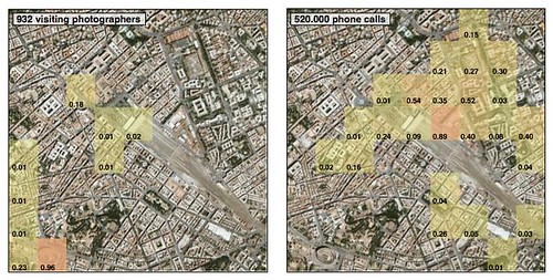
Geovisualizations of the presence of (a) 932 tourist photographers and (b) 520,000 phone calls from foreign mobile phones in the Coliseum and Piazza della Repubblica area from September to November 2006. Both types of data cover the train station area in the proximity of the Piazza della Republica. The values in each cell are normalized.
Posted: October 22nd, 2008 | No Comments »
Today’s New York City mayor Michael Bloomberg announcement of the New York City Waterfalls economic impact marked the end of an intensive project I led over the summer at the MIT SENSEable City Lab. With innovative analysis of digital footprints to describe the evolution of the attractiveness of the Lower Manhattan and Brooklyn waterfront, we contributed to augment a study that used more traditional means (i.e. manual counts and surveys) to quantify who was attracted by the Waterfalls public art exhibit and how much money they spent. Our approach relied on several “indicators of urban attractiveness” inspired from financial indicators and network theory. For instance, in collaboration with Andrea Vacarri, we compared the attractiveness of the main points of interests in New York from the relative strength based on the density of digital footprints; or the evolution of the centrality of the waterfront among the network of points of interest generated by the flows of visitors in the Lower Manhattan area. The mapping of this new type of digital footprint analysis shows the impact of an event to open-up and drive people to new parts of a city over time.
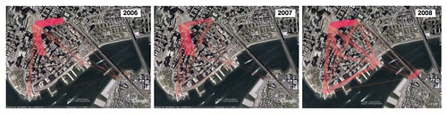
Evolution of the flows of photographers in proximity to the exhibit from the analysis of photos generated between June and October in 2006 and 2007 and June and August 15 in 2008
Besides generating these preliminary research outcomes, there was a lot to learn from running digital footprinting techniques in parallel from traditional studies. The unconventional aspect of this type project leads a city to unbeaten territories where administrative procedure must be created. The data sets and methods must constantly be clearly explained. Liability and privacy issues are the obvious subject that necessitate constant clear descriptions of the data sets and methods used. Of course, in exploratory research that aims at developing the latter, this is not always evident, particularly with tight time constraints. In addition, the applied aspect of this research requests skills to communicate the value of the analysis for the present and the future. A situation I was already confronted in Florence when presenting research results to local authorities and journalists.
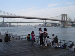
People generating digital footprints and digital shadows this summer in proximity to the NYC Waterfalls
Relation to my thesis: Research outcomes of this work will fit to the core of my dissertation. The overall experience of leading a digital footprint study to quantify the evolution of the attractiveness of an urban space fit with my interest in developing mixed methods to perform post-occupancy evaluations in the future. Unfortunately, in this project I could only rely only on very little qualitative observations.
Posted: October 22nd, 2008 | No Comments »
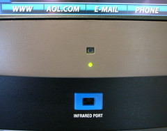
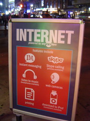
The evolution of the Internet “features” offered in public spaces from the AOL and infrared years (photo courtesy of Julian Bleecker)
to the contemporary times of Skype and iPod connectivity overshadowing the www.
Posted: October 6th, 2008 | No Comments »
After a summer of dense project coordination and urban data analysis, time is slowly coming to frame the content of my PhD thesis dissertation. I plan to submit it in March 2009 with a timeline composed of 3 months to complete the current “deep dig” analysis of digital breadcrums followed by another 3 months early next year of compiling and writing the dissertation. Discussions with my PhD advisor led to the agreement that the dissertation should cover the extensive work I have been leading in the aspects of implicit and explicit human interaction with pervasive geoinformation. In practice it implies framing my analysis of pervasive user-generated content as a core element alimented with more qualitative studies on the perception and generation of location information (with an emphasis on location quality and uncertainty) and the co-evolution of humans with location information. It creates the challenge to keep a flow of thoughts between the different studies, but it allows me to build on the approach to mix quantitative digital footprints analysis enhanced with descriptions from qualitative observations. A mixed approach I would like to document and ponder for my post-academic life.
The next step is to staple my paper together and write a chapter that summarizes the contribution for each work. Then from each contribution see what kind of linking is necessary. My work addresses a few questions created by the increasing amount of implicit and explicit interaction people have with digital infrastructures in the (urban) physical space:
1. How do we co-evolve with the pervasive availability of geoinformation?
2. How do we manage (interpret and generate) the fluctuating quality of geoinformation?
3. How to take advantage of these novel massive amount of pervasive user-generated geodata?
My thesis addresses these question first by describing how the location information provided by pervasive appliances impacts our work practices, a theme I cover in The co-evolution of taxi drivers and their in-car navigation systems (and other more complete paper still in progress). The very different appropriation of the systems raises the issue of the user interpretation of location quality that I categorize in the experiments on CatchbBob! summarized in Getting real with ubiquitous computing: the impact of discrepancies on collaboration and Issues from Deploying a Pervasive Game on Multiple Sites. A fluctuating location quality is part of humans practice of generating and sharing geoinformation as highlighted in Place this Photo on a Map: A Study of Explicit Disclosure of Location Information and Assessing pervasive user-generated content to describe tourist dynamics. I still need to finish my study and publish on the practices of geoannotating and georeferencing information. Despite the imperfections of sensors-based and user-generated geoinformation constantly generated implicitly or explicitly, their aggregation and analysis (following privacy regulation and ethical guidelines) provide novel perspectives on understanding urban dynamics and particularly tourism. I covered the opportunities from the development of softwares to the application of data analysis techniques that I entitled “digital footprinting”. The contributions include the collection, visualization and analysis of digital footprints that reveal tourist dynamics in Leveraging explicitly disclosed location information to understand tourist dynamic: a case study (Journal of Location Based Services) and the analysis of digital shadows and their correlation with digital footprints in Digital footprinting: uncovering the presence and movements of tourists from user-generated content that reveals the complementary perspectives of each data set. Other data analysis techniques on digital shadows allow to Quantifying the presence of visitors from the mobile phone network activity they generate (International Forum on Tourist Statistics, in print) and develop indicators on the urban space that perform Measures of urban attractiveness based on the analysis of digital footprints (in progress). While these approach focus on aggregated data and crowds, specific mobile software developments allow to perform mobility panel studies on a world-wide scale with system that perform World-wide air travel detection (in progress).
Relation to my thesis: Setting a deadline to finish in 3.5 years and framing the work done so far under one umbrella. The challenge will be to link the multiple contributions under a common umbrella. Equality important will be to keep a scientifically honest piece of work that is accessible to people on the edges of academia. For instance, I was advised not to hesitate in referencing to my blog and acknowledge it is a research tool (inspired by Anne Galloway’s PhD disseration).