The Potholes in the Urban Information Landscape
Posted: January 8th, 2010 | No Comments »John Tolva wrote an short essay “Data: our second city” condensing a year of conferences and talks informed by IBM’s Smarter Cities perspective all with a Chicago bent. Certainly also inspired by the texts and talks of Dan Hill and Adam Greenfield, he starts with the observation of the data that now continuously permeates the streetscape (i.e. similar to my new urban actors slide) to propose discuss the near-future opportunities of their presence:
Visualization as to engage the dialogue: “our city planners and citizenry need to be at least as conversant with the language of information architecture as we are, at a basic level, about physical architecture. Call it an aesthetics of data. This is as much a matter of becoming aware of what’s happening around us, of figuring out the most elegant ways of making the unseen felt, of thinking of our urban spaces as I described the interactions at Michigan and Congress“. Our work in Florence is an example of the use of visualization to integrate citizen into the discussion.
Data to empower: “Our plan for a networked urbanism should seek above all to be maximally enfranchising, lowering barriers to commerce and community.”
For this to happen, John suggests that:
We must take up this mantle and be active participants in the design of this networked urbanism. We must make our voice heard. From educating our elected representatives about the opportunities before us, to encouraging our youth — who increasingly live in a world of data — to think critically about their role in the urban fabric, we must embrace this challenge with the same passion embodied in our historical tradition of remarkable plans for Chicago.
However, John could have further suggested that we will need current processes to integrating evaluation tools/techniques/methods/procedures to ensure that our digital infrastructure avoids the mistakes of our physical infrastructure. An urban environment will make the envy not just of building architects but of information architects.
In addition, any strategy should take into consideration the imperfection of the software infrastructure; the kind of “potholes in the urban Information landscape” John describes:
But fissures in a city’s data infrastructure are as consequential as potholes. They are structural failings of a city at the most basic level, in a way that a busted piece of street art would never be.
Think of cell phone outages — “dark zones” — as potholes in the urban information landscape. Or consider GPS brownouts, such as cause error in bus-tracking when the CTA enters the satellite-blocking skyscraper canyon of the Loop. But these examples are minor compared to the real issue before us: how do we proactively build a city of information that is inclusionary, robust but flexible, and reflective of a city’s unique character?
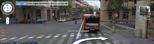
Turn right, … or not. A classic pothole in the urban information landscape
Why do I blog this: Further collecting thoughts for future talks and essays; as well as linking other people’s work with my endeavors. The necessity to educate elected representatives, decision makers, companies and citizens are part of ongoing projects at Lift lab. Beyond developing visualization and workshops to educate and open dialogue between the different stakeholders of the urban space, we develop tools that enable to evaluate urban strategies.