Posted: June 27th, 2008 | No Comments »
Today I gave a talk at the ICING (Intelligent Cities of the Next Generation) workshop in Barcelona entitled “From Sentient to Responsive Cities” (slides). In this presentation I discussed the deployment of new urban actors as instigators of new types of data at the source of a sentient city. These new technologies should not be perceived as drivers of urban change (like often misconceived), but are rather caught up in complex socio-technical assemblages and evolution. They can be used to solve a problem, but might create others therefore failing to contributing to the health of society. That being said, I showcased the use of digital footprints and digital shadows generated by our interactions with these new actors to reveal the invisible (with still many obscurities). In a near future, their visualizations and analysis could very well complete traditional techniques to understand urban dynamics. The real-time availability of these information and evidences extracted from the analysis of these data could lead services part of a responsive city; a city that observes and improves rather than predicts and accommodates. They provide an opportunity to reveal the imperfections of our chaotic cities (and we love them for that) to promote the appropriation of services that have fluctuant quality. This implies a change of approach from the current design of urban services based on the mythologies of a perfect, uniform informational landscape. This approach has some echo in the practice as a quote from a spokesman of the American Public Transportation Association in the news this week reveals: “If you’re late, the public will forgive you if you can tell them how much and why“.
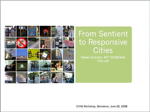
Thanks to Joan Batlle (Barcelona City Council) and Yuji Yoshimura (Barcelona Ecologia) for their invitation
Posted: June 20th, 2008 | No Comments »
This week I gave a talk at Nuria Oliver‘s recently created Multimedia Scientific Research group within Telefonica R&D in Barcelona. In this presentation, I discussed some of my ongoing research work at MIT and Universitat Pompeu Fabra on “Exploiting digital footprints to describe urban dynamics“.
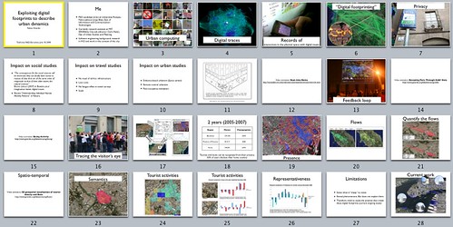
Thanks to Mauro Cherubini and Nuria Oliver for their kind invitation.
Posted: June 12th, 2008 | No Comments »
Extracted from Marc Smith‘s keynote presentation on “Illustrating Digital Traces: Visualizations of patterns generated by computer-mediated collective action systems” at the Third International Conference on Communities and Technologies 2007:
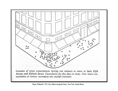
Traditional observation of people communication behavior on the street, from City: Rediscovering the Center by William H. Whyte (1990)
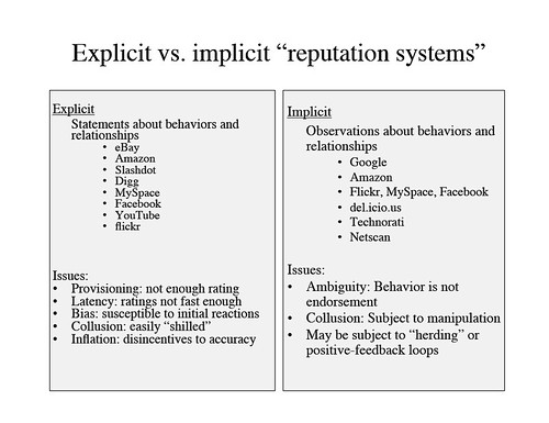
Issues with relying on explicit and implicit “reputation systems”
Posted: June 11th, 2008 | No Comments »
A couple of papers studying users behaviors in the context of online photo-sharing. Each has a specific angle on the data: social science (individual and group cooperation practices), data mining (who is looking at a photo) and visualization (understand the notion of place). I use them to inform the analysis of Flickr users practices to georeference and geotag their photos.
Prieur, C., Cardon, D., Beuscart, J.-S., Pissard, N., and Pons, P. (2008). The stength of weak cooperation: A case study on flickr. CoRR, abs/0802.2317.
Objective: Detail the concept of weak cooperation showing the great variety of uses (stockpiling, social media use, myspace like).
Data: 5M users, 150M photos, users, contacts, groups photos, comments, tags and favorites.
Methods: Distribution of flickr functionalities (contacts, comments, favorites); principal component analysis on correlation matrix to represent graphically the relations among nb photos, nb contacts (in/out), nb favorites (in/out); distribution of number of members and photos among Flickr groups, social graph with members of groups as nodes and proximity function between users from the similarity of the tags they use; define the social density of a group from the density of the social graph.
van Zwol, R. (2007). Flickr: Who is looking? In 2007 IEEE / WIC / ACM International Conference on Web Intelligence, pages 184–190. IEEE Computer Society.
Objective: Characterize user behaviors on temporal, social and spatial dimensions.
Data: 1.83M uploaded during 10 days and viewed over a period of 50 days.
Methods: Use a photo’s popularity to identify social networking and photo pooling. Distribution of photos views per bucket (a bucket groups the photos based on the number of views) 0-10%, 10-20%, 20-30%, 30-40%, 40-50% and > 50%. Same for the temporal dimension slices of time, and social dimension (comments, contacts, pools). Geographic distribution defined with two standard deviations (for the longitude and latitude) and a single value representing the geographic spreading of the photos views with the euclidian distance between the two standard deviations. This value is then applied to the slices.
Dykes, J., Purves, R., Edwardes, A. J., and Wood, J. (2008). Exploring volunteered geographic information to describe place: Visualization of the ’geograph british isles’ collection. In GIS Research UK (GISRUK 2008). Manchester Metropolitan University.
Objective: Understand the way language is used to describe landscape with geotagged photos
Data: 340,000 photographs with titles, comments and other metadata, georeference with at least 1km precision
Methods: Interactive and spatial treemaps of terms. Forcus on scene types (e.g. beach, village, mountain, hill) and scene type descriptors. Chi statistic maps of national trends for the selected combination of scene types. Spatial tag clouds to explore local variation in the terms.
Relation to my thesis: Quantitative methods to understand user practices with online photo-sharing platforms in extensions to works such as Why We Tag: Motivations for Annotation in Mobile and Online Media
Posted: June 9th, 2008 | No Comments »
The launch of Citysense, a real-time social navigation and nightlife discovery application for Blackberry and iPhone confirms the trend of analyzing massive amounts of real-time and historic location data from mobile devices for predictive analytics. The idea is similar to automobile GPS systems sharing and pooling current road speed conditions so that everyone can avoid congestion (see Real-Time Traffic Routing from the Comfort of Your Car). The algorithms behind Citysense indexes the active places in a city and characterized them by activity, versus proximity or demographics, to better understand the context of people behavior. In the same range, using the iPhone’s map and self-location features, as well as information about the prior activities of the user’s friends, Whrrl proposes new places to explore or activities to try. Last year, PARC developed, Magitti, a mobile application that uses a combination of cues to infer her interests. With the time of day, a person’s location, her past behaviors, and even her text messages the application suggests concerts, movies, bookstores, and restaurants.
The recent release of these social softwares is also a signal of a shift from answering “where are my friends” to “where is everybody” or “what is everybody doing” (A theme I discussed in the paper “Leveraging Urban Digital Footprints with Social Navigation and Seamful Design“). But they also raise the questios: are people interested in being entertained with real-time information and can machine learning algorithms provide solutions?

Citysense screenshot on a Blackberry
Relation to my thesis: Sense Networks, the company behind Citysense also developed Macrosense, a direct technology transfer from Sandy Pentland’s work on “Reality Mining” (see Nathan Eagle’s talk at Lift on the subject). It demonstrats the real interest in combining massive amounts of anonymous, aggregate location data to understand people dynamics (see Understanding Human Mobility Patterns). However, for powerful predictions there is still a lot of work to do in 1) understanding what motivates individuals to behave the way they do and 2) how users perceive and interact with the information and recommendation.
Posted: June 5th, 2008 | No Comments »
In the line of Bruno Latour’s thoughts on the consequences of digital traces on social sciences, the current issue of Nature reports in its editorial “A flood of hard data” on the use of mobile-phone technique as an example of how modern information technologies are giving social scientists the power to make measurements that are often as precise as those in the ‘hard’ sciences:
Social scientists have long struggled with a paucity of hard data about human activities; people’s self-reporting about their social interactions, say, or their movement patterns is labour-intensive to collect and notoriously unreliable. In this case, the researchers obtained objective data on individuals’ movements from mobile-phone networks (albeit without access to any individual’s identity, for privacy reasons).
In “Understanding Individual Human Mobility Patterns“, a paper featured in the same issue is an example of this new approach. It reports on the study of movements of 100,000 people following their cellphone signals and found. Quite predictably, it reveals that “most people are creatures of habit”, inclined to move around the same few locations, occasionally given to long hops and despite the diversity of their travel history, humans follow simple reproducible patterns”,
Relation to my thesis: it is rather encouraging Nature reporting on the opportunity that digital traces represent for “It’s not an overstatement to say that these tools are fostering a whole new type of social science — with applications that go well beyond the conventional boundaries of the field.” and their influence on urban planning and the development of transportation networks… and some caution on the new approach that goes exactly in the direction of my thesis and exploring the practice behind the data to better inform the analysis of tourists presence and movements:
The goal of social science is not simply to understand how people behave in large groups, but to understand what motivates individuals to behave the way they do.
Posted: June 4th, 2008 | No Comments »
Barcelona Visió produced a creative 6 minutes documentary on Tracing the Visitor’s Eye, presented in Catalan by my advisor Josep Blat.
Contemplate the Modernista style of the Sagrada Família, the Pedrera and Casa Batlló in the morning, dine on arròs a la cassola (casserole rice) in Barceloneta and round off the day visiting Plaça d’Espanya and Camp Nou may be one of the preferred routes of Japanese tourists who want to get to know the city of Barcelona. Knowing firsthand what visitors see, when, and how they get around the city would be very useful for shops, restaurants and transport services, so that they could adapt to the real demands. A few years ago, to get this information was an over-ambitious dream. Now, new technology has made it possible. The mathematician Josep Blat, together with Fabien Girardin, explains how they have been able to create a map of the routes tourists take, based on information extracted from the photos tourists themselves post on the Flickr website. Science fiction is history!

Posted: June 3rd, 2008 | No Comments »
UCL’s Centre for Advanced Spatial Analysis (CASA) announce the availability of a fully funded PhD studentships on “Measuring and monitoring population diversity and spatial concentration: GeoWeb 2.0 solutions”
Relation to my thesis: Another sign of research getting financed around my thesis topic
Posted: June 2nd, 2008 | No Comments »
The seminal report From Being Human addresses the issues around the explicit and implicit storage of our interactions and activities in public places, while shopping or on the web. The authors question how we will manage and harness the enormous digital footprints and shadows that are being created by and for everyone and cover many subjects are the core of my research.
The scale of the phenomenon
Furthermore, huge amounts of information are being recorded and stored daily about people’s behaviour, as they walk through the streets, drive their cars and use the Web. While much of this may be erased after a period of time, some is stored more permanently, about which people may be naively unaware. In 2020, it is likely that our digital footprints will be gigantic, distributed everywhere, and in all manner of places and forms.
Explicit digital footprints (emptying the shoeboxes)
The decreasing cost and increasing capacity of digital storage also goes hand-in-hand with new and cheap methods for capturing, creating and viewing digital media. The effect on our behaviour has been quite dramatic: people are taking thousands of pictures rather than hundreds each year. They no longer keep them in shoeboxes or stick them in albums but keep them as ever growing digital collections, often online. The use of Web services for photo-sharing is transforming why we take photos by reinventing what we do with them.
Implicit digital footprints (our digital shadows)
Data are also being collected on our behalf or about us for no apparent reason other than because the technology enables it – our digital shadows, if you like. Personal video recorders (PVRs) record TV programmes chosen by the viewer but also automatically store them based on the viewer’s viewing profile or other criteria. Similarly, new devices are beginning to appear, such as SenseCam (see ‘A Digital Life’, below), that can automatically capture all kinds of traces of everyday life, in the form of images, video, conversations and sounds. The same is true for GPS devices which now appear in cars, in mobile phones and even embedded into clothing. All of these are capable of producing and storing large volumes of location data about our comings and goings without any conscious effort on behalf of their owners.
Data are also being deliberately recorded about us by governments, banks and other institutions using technologies such as CCTV, ATMs and phone logging. In the UK, CCTV often generates recorded ‘feeds’ of conversations and actions, as well as logging exactly where these conversations and actions took place. Some workplaces have meeting rooms that capture the content of and activities around discussions held within them. Many public debates are recorded for posterity by editorialising CCTV: in the UK, the Houses of Parliament are captured on behalf of the nation by the BBC, for example. Most people’s financial transactions are logged too, each time a credit card is used. International phone calls from the US are routinely tapped and analysed for suspicious ‘terrorist’ topics (with advanced word-recognition software allowing interrogators to locate possible conversational threads which are then focused on more attentively).
Questions on the new challenges for how we design technologies
But digital records are merciless: a silly prank captured on a mobile phone and then uploaded to a photosharing site may haunt someone for the rest of their lives in a way it never did before.
- Will it be possible for people to delete digital memories captured by others? Now that there are digital tools that can record everything we say or do, how will this affect our own abilities and ways of remembering?
- What tools and technologies are needed to effectively manage vast quantities of personal data?
- How can the privacy and security of digital footprints be ensured to prevent misuse but at the same time allow them to be shared with others when needed?
- How do people find out about their digital footprint and what tools should be provided?
Questions of broader impact
- How should society manage the storage and access of human data ethically and responsibly?
- Will people have the right to have information removed from their digital footprints?
- What are the legal implications of a growing digital footprint that maintains a record of our present and past?
- Should people be informed of the information that is being captured about them, who has access to it and how it is being used?
- To what extent do we need to design technology that allows people both control and feedback about what kinds of data are being monitored?
Relation to my thesis: The report address the notions of implicit and explicit digital footprint (with the term digital shadows for the notion of implicit footprint) and the implications in for their management, the privacy of the people generating them and their misuse (in extension to Be Counted! Return Your Census!). However, it does not mention the benefits beyond the individual (storing for memory) and social (life sharing, coordination) interests such as better understanding societies (the massive consequences on social sciences) and cities.
Posted: June 2nd, 2008 | No Comments »
At the RUDI’s knowledge-sharing event on technology, people, space and place, MIT PhD candidate and US Director of Space Syntax Noah Raford gave an overview of the implication of real-time data collection on urban planning and design: “Real time data collection methods, parametric modelling at the urban scale, and remote control urbanism“. Noah grounds his work on space syntax techniques and Evidence-based urbanism that is making decision based on advanced available research and practices. The term is borrowed from medicine
“Evidence-based medicine is the conscientious, explicit and judicious use of current best evidence in making decision about the care of individual patients.” Centre for Evidence-Based Medicine
However, currently land use and space activity data are collected still through very traditional means (e.g. students sent on the street to perform manual counting) that limits the emergence of evidences from the statistical relations between variable (e.g. What is the effect of spatial layout on movement? how does it perform?). With the increasing availability of “intelligent bricks” or “spimes”, the process of data collection is improved and reveals new (real-time) aspects of the city (e.g. cabspotting, real-time rome, subway smell map, searchable cities (mapdango), mobility on demand). However will the interfaces giving access and communicating the analysis of these data helps decision makers in improving citizens conditions?
Relation to my thesis: Even though Space Syntax do not represent the traditional urban planners, it is a clear signal in favor of my work that they become interested in unconventional data sources. Noah suggest that urban designers have always been interface designers. I would humbly argue that for the type of “remote control urbanism” he describes, the interface between technology and people requests other practices and methods that urban designer have applied to place and space so far. As a consequence, they should start to get help from software engineering techniques (e.g. quality assurance) or interaction design methods (e.g. involvement of “users”, ethnography). Related to Report on the Real-Time Cities Round Table.
