Posted: December 19th, 2008 | 1 Comment »
I have been casted several times as an hybrid researcher; and not the kind of hybrid that emerges from research intersections, but rather hybrid from the conduct of my research. I am part of a bread of researcher who practice at the World Wide Lab, both crawling against and surfing on the top-down model of academia, beyond the greenways of its campuses. The type of researcher that traded away a desk with ethernet connexion on a campus for three affiliations and temporary officies. The enablers of this mutation are clear: a) my laboratory has extended its walls to the whole planet. b) instruments and data are “out there” for people without an academic affiliation to query and c) multiple channels of communication and debate such as this blog are now open. But what really gives me an edge over knowledge emerged from a confined center of “rational enlightenment” is the participation and contribution to hybrid forums (such as Lift) where I can mingle with an Adam Greenfield, a Julian Bleecker or a Daniel Kaplan or other members of bestiaries of researchers, designers, artists, thinkers, engineers. A great majority of them never or stopped following the scientific path and do not hang out in the academic world, but are nevertheless influential and how I frame my questions or interpret results.
Inspiration: the World Wide Lab by Bruno Latour
Relation to my thesis: The participation to a debate that goes beyond science and its representing nature (i.e. accuracy, precision, and reference) allows to test the motivations, rational, limitations, significance of my research work. This blog has been a fantastic tool to develop this face of the hybrid researcher; I plan to highlight it in my dissertation.
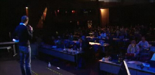
At Lift. “A crucial part of doing science is formulating the questions to be solved; it’s clear that scientists are no longer alone in this endeavor“. Latour
Posted: December 17th, 2008 | 2 Comments »
In an era of global competition, every aspect of a city that contributes to its desirability or undesirability is been increasingly regarded as a key factors to maintain and strengthen its attractiveness and by consequence its competitiveness. A city’s attractiveness is determined by a wide range of elements based on their own wealth, security (i.e. The Safe City By Leo van den Berg), history, cultural assets, and excellent landscape, measured with quantitative data such as in Richard Florida’s work and the indexes of Mercer, and the UN’s State of the World’s Cities, Quality of “Business” Life. Character, identity and uniqueness are also crucial ingredients in a city’s attractiveness, which can only be exploited by careful planning at a local level and highlighted in more qualitative surveys such as FT’s Cities of Dreams and Monocle’s top liveable cities.
These indicators inform the urban policies and politics of major urban areas and polycentric metropolis with implications on the management of these places and the practice of urban planning and urban design (see Manuel Castells Talk on the Implications of Networks on Urban Planning). The strategies for enhancing attractiveness include city-centre redevelopment, cultural policy, the role of events, city promotion and infrastructure. They were characterized by the so-called “culture-led” regeneration of the New York City Waterfronts and its 4-months Waterfalls public art exhibit that has been playing a role in enhancing city image and achieving economic deindustrialisation of the piers in Lower Manhattan and West Brooklyn. Similar strategy use the concept of “event city” that has come to signify to policy makers that special events can be used to give a specific character to the city that hosts them. Other examples take the forms of new cultural infrastructure, including galleries, theatres and concert halls, as a tourist attraction and a community platform for culture-related economic activities to expand.
The impact of these strategies is only partially measurable (when not too costly), although it is generally accepted that there is a conspicuous impact of these projects on city image, which is reflected in increases in the number of tourists and the demand for tourism-related services. However, these strategies could play negative roles as cites with large suburbs where centers become centres of consumption, apart from production; they might become less about living rather than becoming a place to visit for shopping and eating out, to take part in social events, to have cultural experiences at movie theatres, concert halls and museums, to meet and communicate with others.
In other words, city centers have been the focal point of citizen’s urban life. Therefore, the lack of monitoring of their attractiveness could be regarded as an immediate threat to the liveliness of their economy. Measures from urban data (e.g. land use, census, traffic data) and statistics (e.g. NYC’s Sustainable Streets Index) traditionally feed the suspicions and are less traditionally augmented with the systematic collection of people’s experience, as suggested by Marek Kozlowski’s PhD thesis Urban Design: Shaping Attractiveness of the Urban Environment with the End-Users that aims at obtaining subjective views of end-users and integrating this information into the urban design process.
My work on urban attractiveness proposes a third, complementary avenue that exploits the logs of people’s explicit and implicit interactions with urban infrastructures as evidences of the evolution of attractiveness of a space. The analysis of the temporal density and spatial distribution of digital footprints could help ensuring the sustainability of a city attractiveness by keeping indicators on the evolution of the experience of the space. They are an opportunity to inform urban designer and policy makers to enhance urban quality through post-occupency evolutions. Finally the development and assessment of strategies to enhance urban attractiveness involves of a wide range of local stakeholders and strong partnership among. The visualization of the evidences extracted form digital footprints can help the discussion that contribute to extend the contextual knowledge and deepens understanding.
An evidence of temporary low attractiveness of a space in relation to other areas?
Relation to my thesis: Further motive and ground my latest research work. Keep on highlighting that “it seems that the interface with technologies and networks is still not taught in land use planning and urban design“.
Posted: December 12th, 2008 | 1 Comment »
Following the MIT SENSEable City Lab’s footsteps (RealTime Rome), Orange Labs and Faber Novel developed Urban Mobs, a tool showcasing their “popular emotion cartography” through the analyzes and visualization of citywide cellular network traffic activity. The featured chronotopes include uncovering “visitors” aggregated digital footprints in cellular network activity generated by foreign phones, linking mobile activities with public transport in the cellular network activity in the Paris subway, and revealing aggregated digital traces in the map of handovers generated by the movements of mobile phones during the national music day.

Visualization of mobile phone calls in Barcelona during the Euro 2008 final
Relation to my thesis: Urban Mobs proves that Real-time Rome work is a pervasive solution that can be replicated to multiple cities and countries to mirror an aspect a city dynamics. Now the goal is to go beyond beautiful visualizations of dynamic urban data and extract their value added information as well as understand their applications and implications.
Posted: December 10th, 2008 | No Comments »
A couple of videos of MIT SENSEable City Lab members. First, in the Canadian Discovery Channel describing the research focus and approach with examples of the New York Talk Exchange and CopenCycle projects. And then in Seed Salon, Steven Strogatz and Carlo Ratti discuss whether building and analyzing human networks can help us overcome the current mathematical understanding of complexity (e.g. study feedback loop as a complex system). There are still a lot of coarse grained laws of urban phenomena to be discovered, and still very little has been done in Network Theory to study networks in geographical Euclidean space.
Posted: December 9th, 2008 | No Comments »
The exhibition Situated Technologies: Toward the Sentient City aims at imagining alternative trajectories for how various mobile, embedded, networked, and distributed forms of media, information and communication systems might inform the architecture of urban space and/or influence our behavior within it. Curated by Mark Shepard and organized by the Architectural League of New York, it will open in September 2009 with 5 commissioned projects that examine the broader social, cultural, environmental and political issues within which the development of urban ubiquitous/pervasive computing is itself situated. One of them, Trash Track, proposed by the MIT SENSEable City Lab (led by Eugenio Morello) will explore how pervasive technologies can help expose the challenges of waste management and sustainability:
Trash Track is inspired by the NYC Green Initiative, which aims to increase the rate of waste recycling in the city to almost 100% by 2030. The project considers how pervasive technologies can help expose the challenges of waste management and sustainability. Trash Track will tag different types of waste and follow these through the city’s waste management system to reveal the end-of-life journey of our everyday objects. Whereas most focus in the economic system is on the supply chain, Trash Track will help underscore the environmental impact of consumer waste by visualizing the waste chain, revealing the ultimate destination of the things we throw away.
In other words, the goal of this project is to reveal the “removal-chain” of our everyday objects and waste with a citizen science approach. This approach raise the concerns of using technologies to solve the very problems they have created, as recently discussed by Anne Galloway in “The Rise of Sensor Citizen“:
For example, projects in this domain rarely, if ever, question the environmental or political impacts of the technologies they seek to employ for environmental and political activism. For example, the United Nations now estimates that almost 50 million tonnes of electronic waste are discarded each year. While the environmental costs of toxic e-waste are substantial and can be added to the environmental impact of manufacturing new electronics, the problem is exacerbated by a variety of related practices that disadvantage developing nations. While all of the projects discussed above advocate using technologies for socially, politically and environmentally positive ends, they also implicitly support existing consumption practices in the developed world, and hide the role that technological progress has played in creating the very problems they seek to improve.
Relation to my thesis: The brainstorm session to develop the Trash Track proposal were an excellent learning experience to understand designers, architects, engineers, urbanists concerns and practices, as well as cultural differences in the approach of people as sensors and urban sustainability. I could not help raising the ambivalence of using dust networks that transforms into e-waste to reduce dust. It will be the fascinating challenge of Track Trash to give a counter example to these concerns. I imagined a scenario that solely focuses on the design of pervasive electronic devices that highlight their own removal-chain and help their recycling.


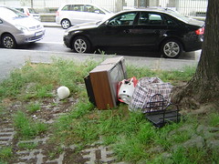
E-waste removal-chain in contemporary cities
Posted: December 5th, 2008 | No Comments »
I has been 9 intense months since I left Barcelona for MIT. Time has now come to move back to Europe and engage in the last 6 months of my PhD, focusing on a last round of rigorous data analysis, defining an overall coherence and writing the dissertation. My stay at the SENSEable City Lab produced a fair list of highlights and professional satisfactions including:
I communicated results of my research work at AAG, GIScience and Tourism Statistics, but enjoyed almost as much responding to the invitations of the non-academic venues where I could express my skepticism, thoughts, questions and critics that do not fit in traditional academic outputs:
All these different activities, symbol of a hybrid researcher at the crossroad of multiple domains, certainly taught me a lot. I can highlight the most obvious.
Relations to my thesis: My stay in Boston provided me the necessary boots to finish my PhD in 3.5 years with a good set of skills that I plan to use after the defense of my dissertation. The affiliation with the MIT SENSEable City Lab has helped opening doors and I cannot thank its director Carlo Ratti enough for giving me the opportunity to engage into research with one of the finest team that studies the relations between ubiquitous technologies and the city.
Posted: December 4th, 2008 | No Comments »
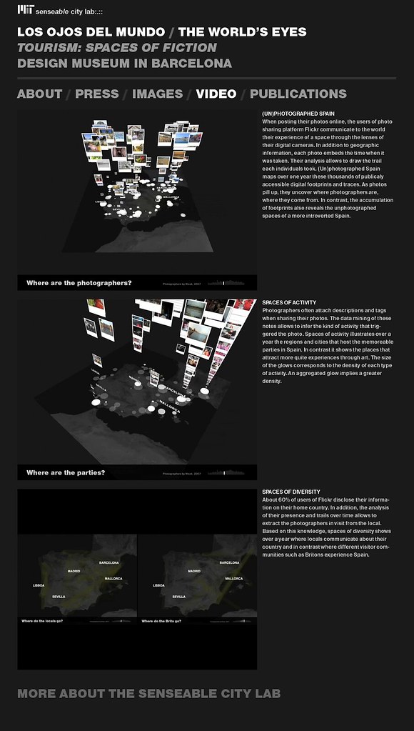
This week opened the new Design Museum in Barcelona with the exhibition Tourism: Spaces of Fiction that features los ojos del mundo (The World’s Eyes) a project I led in collaboration with designer David Lu and the MIT SENSEable City Lab. Based on my research work that analysis Flickr georeferenced photos to uncover tourists density and movement, we developed several spatio-temporal visualizations that give a novel perspective of tourism in Spain and its neighbors:
Los ojos del mundo provides insights to these question from the digital photos publically shared on the web by people visiting Spain. Through data mining and visualization techniques, it uncovers the evolutions of the presence and flows of tourists. As photos pill up to reflect the intensity of the tourist activity, they uncover where tourists are, where they come from and what they are interested in capturing and sharing from their visit. The analysis and mapping of this data allows understanding the attractiveness of leisure cities and their points of interest. In contrast it also reveals the unphotographed regions of Spain still free from the tourist buzz.
The project web site contains the visualizations of three main stories of the piece.
Relation to my thesis: Transforming a research work into a design piece was a challenge that implies speaking a different language in phase with designers and architects. In this project, it meant emphasizing the communication of the data on the esthetic and the experience. In the end result, it was important to show the human side of the data and reveal the content of the pictures that slightly neglects the analysis of the density and movement of photographers.
However, along the process, David developed some impressive concept sketches that could actually return to the research world as part of a visual analytics tool for the study of digital footprints. The most promising include Pilgrimage photographer trails versus all photos, Spain as a grid, trails with camera movements, accumulated density and trails, density in Barcelona, trails cabspotting style, and aggregated path with real-time density and photos.
I believe this is a good example of how research can get strength from design and vice versa. This type of “urban demo” certainly helps in raising the attention beyond my research community on the potentials and implications of my work, or in other words it can help “stretch the imagination” of a large public.
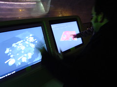
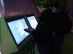
Stretching the first visitors’ minds
Posted: December 4th, 2008 | No Comments »
While in Paris, I was kindly invited by Bruno Marzloff of Groupe Chronos to participate to their forum on “La carte. Des territoires à inventer“. My contribution entitled Intégration des technologies et de l’intelligence ambiante dans les environnements urbains compressed in 15′ a few thoughts and studies extracted from my research on the integration of ubiquitous technologies in urban environments. A broad topic that I already intended to cover in an interview to Groupe Chronos “Réduire l’incertain, Révéler le réel-réel“. I discussed the emergence of new urban actors and the massive amount of digital footprints we produce in their implicit and explicit contact. Besides the obvious concerns on privacy, these new dynamic urban data provides opportunities to improve the management in real-time (remote control urbanism, feedback loop), the planning (evidence-based urbanism) and design (post-occupency evaluation) of cities of the near-future. After a couple of example of the applications of new potential types of urban analysis, I fed the debate on questioning some of the techno-determinism and utilitarian rhetoric and wondering that by trying to solve problems we actual contribute to the good of society. I argued with a practical example from my study of taxi drivers in Barcelona and the co-evolution with their satellite navigation system (different appropriation and evolution in the use depending on their experience of the city).

The 1-hour discussion (summarized here) that follow the interventions of the speakers revealed how much maps are no more the speciality of cartographers, geographers and urban planners. As they become manageable and “habitable“, they are now part of the thoughts and practice of engineers, architects, social scientists, artists and philosophers. The obvious first challenge to avoid confusions have this kind of heteroclite crowd to speak a common language and share common references. We are still far from that state, and that’s probably what made this forum fascinating to attend.
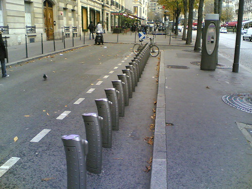
In relation to my work, the obvious subjects discussed were about the ownership of the generated digital footprints (the user who produces the, the service providers who deploys the infrastructure, the analysis provider who adds value? the local authority that manages the space?) and who is allowed to access them. A classic example is the tension between JC Decaux and the city of Paris on the ownership of the usage data of the city’s bike sharing system. One sure thing, is that not many institutions claim that their job is to analyze and add value to these data. Even Orange France sells considers their business as provide of brute data instead of provider of urban information. For instance they sell their cellular network traffic data to provide real-time road and highway traffic information.
Beyond the acknowledgment of the power of new digital maps to draw attention (e.g. chronotope of visitors data in France’s reveals the heartbeat of the country) it becomes necessary to think about their real use and misuse. For instance who will be the hackers of these new territories? who will play the role of digital garbage data collection? who will manipulate them for their own interest? All this considering that we, in general, show poor skills in actually reading maps and we interpret them in a very individual way based on our experience with the physical space.
Thanks to Bruno Marzloff, Léa Marzloff and Julie Rieg for the invitation! It was a great pleasure to meet for the first time Loic Hay, Frank Thomas, Bruno Caillet and Hugues Aubin.
Posted: December 4th, 2008 | No Comments »
I was at the OECD headquarters in Paris to attend the The 9th International Forum on Tourism Statistics. The conference covered the main themes related to the collection and analysis of quantitative tourism data, from the classic issues on visitors survey (e.g. border surveys, hotel surveys) to the coordination among countries through Tourism Satellite Accounts (TSA) to produce more advanced tourism statistics. These methods need to keep on adapting to the constant evolution of tourism and tourists behaviors. For instance, the current demographic evolution with western countries getting older produces new tourism services and reduces seasonalities. In reaction there is progress in the automatic collection of data to deliver short-term estimates in demand and supply data. However, the unique use of these traditional methods raise the risk of missing emerging phenomena and changes in tourist behavior such as the raise of trips with shorter stays or concerns in sustainability.
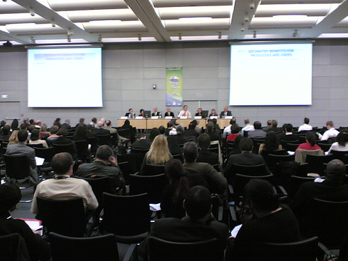
9th International Forum on Tourism Statistics at the OECD headquarters
In response to this evolution that requests new methodologies to capture tourist behaviors, I participated to the session dedicated on “new approaches to data collection from the supply side”.
As is the case for most or all fields of statistics where data is collected from the economic actors, there is an increasing awareness of the respondent burden. Statistical offices try to reduce or control this respondent burden by finding more efficient ways of collection the primary information (e.g. e-surveys) from for instance the accommodation establishments. To obtain more information on e.g. tourism flows or tourism activities, data producers can make use of registers or other administrative sources and combine them with the survey data.
Such sources can be general purpose sources (for instance to obtain more detailed geographical information such as urban versus rural tourism) or can be tourism-related sources (e.g. specific tourist taxes or eco-labels awarded to enterprises in the tourism sector).
This session wants to contribute to exchanging national or regional practices that are not entirely linked to country or region-specific information systems and therefore have relevance for a larger group of tourism statisticians. In addition, this session also aims at getting a better understanding of estimations methods for private or non-rental accommodation, to complete the statistics on collective accommodation. Indeed, a very significant share of tourists stays in private rented accommodation or free accommodation. To get a comprehensive insight into the total tourism flows into a country, estimates of these less visible types of accommodation are indispensable.
I presented the paper Uncovering the presence and movements of tourist from user-generated content (en français) in which in discuss the opportunity in using implicit (cellular network traffic) and explicit (georeferenced photos) digital footprints to uncover novel evidences and anecdotes on urban tourism (slides of my talk):
In recent years, the large deployment of mobile devices has led to a massive increase in the volume of records of where people have been and when they were there. The analysis of these spatio-temporal data can supply high-level human behavior information valuable to social scientists, urban planners and local authorities. This paper explores this hypothesis by reporting on new information revealed by this pervasive user-generated content. We present novel techniques, methods and tools we have been developing to explore the significance of these new types of data. In a case study of Rome, Italy, we showcase the ability to uncover the presence and movements of tourists from geo-referenced photos they explicitly make public, as well as from network data implicitly generated by users of mobile phones.
In a similar line of research Michel Houée (Odit France, France) presented an exploratory work on Estimating foreign visitors from highways toll payments. This methods used credit cards payments at French highway toll stations as digital footprints of visitors in transit. Thanks to the merging of estimates from all cooperating networks, it is possible to . The analysis of these data give produce a global picture of the visits for each toll station serving the French territory, in terms of volume as well as in terms of proportion of the total foreign visits. For instance it gives insights on the split by nationality of visits of a specific tourist location over a whole year, point out the differences of monthly seasonality profile among the nationalities, and when the cooperation is ancient like with the ASF network, it is possible to analyze visit trends according to the nationality. The first major validation consists in checking the accuracy of the estimation of the traffic of each nationality during the survey period as compared to the counts
Using the information at toll barriers along the networks at peak periods of visit of France, it is possible to identify the main routes followed and to observe how the traffic decreases progressively from the entrance gateways up to border points of exit from the French territory (figure below).

Germans in summer: a high proportion of transit towards Spain
A flow that I also capture when entering Spain from France with my Flickr data gathered for the south of France, Spain and Portugal (figure below, second map from the right).
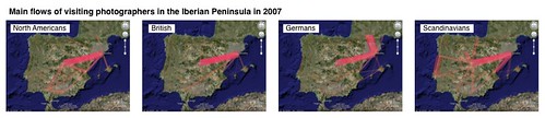
Main flows of visiting photographers in the Iberian Peninsula in 2007
My work on georeferenced photos and cellular network traffic analysis in Rome was rather well perceived as a potential cost alternative approach that can improve the timeliness of the data collection. The limitations are known, the data do not cover exactly a territory and needs strong calibration with more traditional data with respect to privacy. However, they contain some evidences and anecdotes that add “energy” (i.e. a more qualitative angle, and reactivity) to analysis based on traditional quantitative data. This goes well with the utility to build tools to support decision-making but also support a discussion process.
Relation to my thesis: my works frames well with current concerns in the domain of tourism statistics does not want to miss emerging behaviors (influence of ICTs on tourism) and trends (use of ICTs to grasp these behaviors). Solutions based on the analysis of digital footprints can potentially capture what traditional methods can’t, in a cost and time effective manner.