Posted: March 29th, 2009 | No Comments »
An intriguing paper in the nytime “Wikipedia: Exploring Fact City” builds an analogy between Wikipedia and a city. Like a city, Wikipedia is a tale of spontaneous organization and achievement because it mimics the basic civility, trust, acceptance of a city. The author Noam Cohen elaborates in trust with references to Jane Jacobs observations of sidewalks and rules that govern them:
It is this sidewalk-like transparency and collective responsibility that makes Wikipedia as accurate as it is. The greater the foot traffic, the safer the neighborhood.
The concept of acceptance is developed with reference to Lewis Mumford’s “The City in History,”
Even before the city is a place of fixed residence, it begins as a meeting place to which people periodically return: the magnet comes before the container, and this ability to attract nonresidents to it for intercourse and spiritual stimulus no less than trade remains one of the essential criteria of the city, a witness to its essential dynamism, as opposed to the more fixed and indrawn form of the village, hostile to the outsider.”
Why do I blog this?: Working on a project that propose the treatment of a city digital infrastructure with the same approach of its physical infrastructure (i.e. enable rather than structure urban life). Some thoughts in this article can support my argumentation. Digital infrastructure could relay on these approaches of trust and acceptance to enable rather than authoritatively structure/frame/contain the intercourse and spiritual stimulus that make living in a city possible.
Posted: March 14th, 2009 | 1 Comment »
In relation to the visualization to raise the awareness on the dynamics of bicing from openly available data, Aleix Ruiz de Villa has developed an algorithm to improve the distribution of the bikes. The solution, inspired by the classic traveling salesman problem, simulates the movement of the trucks that redistribute the bikes to work on the best routes to perform the job in less time. Besides the theoretical problem, the major issues hides behind the complexity of the city. So far Aleix has worked on the historic behavior of bike stations, simplifying the problem to 100 stations.The specifications and logistics of bike-sharing systems is coming to a science, and so far the citizens have been leading it. Alex decided to work on it observing the trucks going around the city and thinking there might be a more efficient solution.
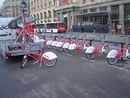
The “traveling salesman” of the XXI century
Posted: March 13th, 2009 | 1 Comment »
To complete my PhD dissertation that will be based on a series of papers, I am writing a journal version of my study presented at last year’s AAG: The co-evolution of taxi drivers and their in-car navigation systems. Besides improving the details that describe the research method, I need to rephrase the elements of co-evolution I aimed at capturing, re-categorize the findings and work on a discussion section that compares the findings with related works and link them to implications consideration for design. A revamp I dissect below.
Motivations
The extensive distribution of satellite navigation systems represents the first massive adoption of location-aware system by the public. However, the market success also translates into documented poor integration of the technology into the practice of driving (e.g. distractions that create accidents, frustrations due to the uneven quality of the geoinformation). From this observation, we hypothesize that users of satellite navigation systems overcome these types of problems by both adapting to their systems and adapting their systems to their needs. First we wanted to report on evidences of this co-evolution (theorized in Orlikowski, 1992a; O’Day, Bobrow, Shirley, 1996, Ackerman, 2000) and then describe the detected implications (e.g. (de-)skilling factors on the knowledge of the city and social relationships, modification of the wayfinding practice, new relations to the environment). An ethnographical approach provides an appropriate analytic angle to examine user practices in context and situated activities (need stronger arguments here!). We argue that our observations and interpretations can be valuable to designers of next generation location-aware systems particularly to understand how a) users create over time unanticipated use to better fit their need, if the system is capable of only partial satisfaction; b) a location-aware system effects the interaction of the user with their environment (social, physical, informational); c) the implication of the adoption of location-aware system on potential for future design. An example in Hutchins cognition in the wild is the slow evolution of navigational tools. For example, the Mercator projection for maps simplifies navigation calculations, and its creation was an act of tool adoption and co-evolution.
Phases of co-evolution
We analyzed this co-evolution for three different phases
- Acquisition: why and how this new technology gets integrated into other artifacts and how, over time, it impacts the use of these artifacts;
- Expectation gap: how the reasons to acquire are matched in practices and where are the expectation gaps;
- Evolution of the appropriation: despite the gaps, how does the practices evolves in relation a) to the awareness and reactions to the limitations and imperfections of the system; b) to driver’s knowledge of the environment; c) to the access to geoinformation both from the system and other artifacts.
Approach, method and participants
So the market success of makes relevant phenomenon to study how people integrate pervasive geoinformation into their practices in the context of their work. What was even more appealing was to perform a systematic study of one type of early adopters, the taxi drivers in Barcelona (available in a large number of the 10,400 licensed cars), who have massively adopted the technology the last few years. This context is precisely relevant to the research on location-based systems because it provides evidences, outsides of the laboratories of their impact and implications, we believe necessary to feed the design process. The study of in-car navigation systems are typically interested in usability issues with an experimental angle. Rather than focusing on the device, we are interested on the practice with mobile and location-aware devices (see Understanding mobility contexts), on the losses and opportunities, and considering a full-circle perspective (Chrisman, 2005)
In our ethnographically-inspired study, we collected empirical evidences from 12 taxi drivers (11 males, 1 female) with a working experience from 2 to 20 years. In a first phase, we conducted semi-structered interviews at the Barcelona airport parking lot dedicated to taxis. This site provided a good setting to get in touch with taxi drivers, because they often must wait there for more than 30 minutes. During this period, they fill the time discussing, playing (e.g. chess, scrabble, golf), cleaning their care, taking a refreshment and eating. The navigation system had been purchased and used by the informants for a least 6 months. Interviews alone did not suffice, as the informants necessarily selective in what they describe or think is important to discuss. Therefore, they complement additional situational insights from observation of driver work settings (e.g. artifacts used) and behavior (e.g. engagement with geoinformation) while driving. Acting is customers, we requested rides from and to a railway station, a major hotel and an address on one of the many very narrow streets of the Gracia neighborhood. Each informant participated in one session, lasting approximately in from 45 minutes to 1 hour, divided in half with situational insights then complementary semi-structured interviews in the other half.
Despite the small sample of taxi drivers, we were able to collect rich data consisting of photos of work settings (to record the eco-system of artifacts), videos of taxi rides (to capture key moments of access to geoinformation) and written field notes from the semi-structured interviews (analyzed and compacted after each session). In our analysis consisted in a careful reading of the different materials and highlighting parts that were related to the phases of the co-evolution we wanted to focus on. We organized the relevant parts into common themes, and coded the documents using the emerging themes. The sessions were conducted in Spanish and we provide the closest translation for this paper. We summarize the findings extracted from these themes in the following section.
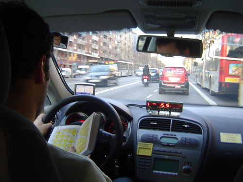
After a red light, in proximity to destination, a taxi driver is about to close his “Guia” after checking the location of a street number. The navigation system is in passive mode.
Findings
Addition to an existing ecosystem of artifacts
The navigation system completes an arrangement of artifacts proving layers of geoinformation to support the job. With our observations, we were able to categorize detected the real-time information sources with the sat-nav system, dispatched radio, electronic booking system, mobile phone and radio. Another category of artifacts provide more static information of the city; the newspapers to keep the knowledge of events and activities in the city up to day, scribbled list of “unofficial” points of interests requested by customers such as the strip clubs, and above all the street directory and map of Barcelona “Guia Urbana de Barcelona” generally kept at reach on the passenger seat, above the dashboard or the interior storage compartment. (Need a table to describe the artifact, its purpose, context of use and the evolution of this ecosystem.
Serenity over efficiency
In the past, taxi drivers face moments of uncertainty when a customers take them to a village or unfamiliar areas of Barcelona, such as the multiple suburban business areas that emerged from the ground in the recent years. Nowadays, there is a consensus that a satellite navigations system is an unbeatable tool when it come to reaching a specific destination in a village and leaving it and it is a strong reason for purchase. But it is not really to be more productive and hence earn more, rather than feeling more serene in appropriately doing their job. A tool not to make more money, nor to improve the efficacy, but to tranquilize, ”I can go everywhere and relax” said informant X and “the fear of getting lost with a customer I felt in my stomach now disappeared” (informant Y). Other drivers mentioned that it does not only tranquilize them but also their customers ”they know I cannot cheat them with it”, “it reassures them that I go to the proper destination”. This feeling of relying on a “companion” for critical situations reveals particularly when informants referrer to it as a “he” (and their car as a “she”). That does not prevent them in keeping it most of the time in the glove compartment and retrieving it only the times it is necessary.
The phases of wayfinding
The wayfinding practice takes place in 2 main phases. For the “to go” phase in which the driver takes the proper direction and the “to arrive” phase in which the precise drop off location (the number of the street, a monument, a corner) necessitate different geoinformation at a different granularity. [...] For a ride to a rather unknown destination, drivers seem to accesses the geoinformation as in a “funnel”. First, there is a tendency to quickly retrieve in the paper-based street directory the area of the destination point. If the paper map does not provide enough information such as reference points to precisely arrive at the area, the drivers we observed engage with the navigation system. No detailed information are requested at that moment of the ride. It is only when approaching the destination area, that the exact address in the navigation system is entered. Informant X explained that he engages with the system at that moment to avoid the often misleading information on the path to take. Indeed, a taxi driver applies several paths depending on the time of the day and circumstances (e.g. traffic, weather conditions, preference of passenger).
An altered learning process
In the past, the driver would open the “Guia” and browse the index of streets and points of interest to get access to a map of the area comprised by the destination. The book was one way to learn the city by doing. Another big part of the knowledge drivers acquire come from the customers themselves, as they communicate the tricks and secrets that official books and commercial systems do not disclose. As the experience drivers contain most of the knowledge of the city in memory they rarely return to the Guia. In fact, they prefer using their sat-nav and open the Guia only as fail-over (e.g. when the system does not contain a street number or lacks of information). Even after 20 years of experience, one drivers still perceived reading the Guia as a demanding task. Compare to that, “hitting the screen of his Tom-Tom is a pure pleasure“. Experienced drivers only rely in the system (sometimes keeping it in the glove compartment – or only use it to keep track of their speed) when driving to unfamiliar destinations, which after 20 years only happens rarely. The system is not source of learning but rather a punctual saver.
The integration of the satellite navigation system altered the learning process of the city from three main disruptions: the necessity to assess the quality of the geoinformation, the imputation of some social interactions and the ability to temporarily disengage with the environment:
- Assessing the quality of geoinformation
Taxi drivers with a short job experience express mixed feelings about their experience with their sat-nav ”It is like my mobile phone, sometimes it does not work well”, “it is a potential problem” in terms of quality of services and precision of the information. Their demand of accurate information quickly reached the limits of the systems and the inaccuracy of the system directly impacted the quality of their service. Because they had to deeply rely on it in the beginning, they have learned when not to rely on it. For instance, informant X could name me the places where he experienced the navigation information to be absolutely irrelevant (e.g. get access major squares). But that does not make them learn the city. In consequence, they embrace the use of the “Guia” which is “more accurate and complete” for their job, particularly when it comes to providing a detailed index of streets, points of interest and city-related information.
- New engagement with the environment
As drivers cannot completely rely on their navigation system, they have to form their knowledge of the city to improve quality of their service and relax. One mean translated into leaving their navigation system system on passive mode to learn the street names or identify the present of fixed speed measurements radars as they appear on the screen. Keeping the system on passive mode, also enables the driver to disengage with the environment for a while knowing that the screen will give a proper position. In the past, drivers would count the number of streets to cross before making a turn.
- Social amputation
A major part of about learning about the city comes from the interaction with the customers. It is still a tradition for a taxi driver to ask “how do you want to go there?” and rely on the direction given by the customers to avoid any complains and learn the tricks to navigate. The presence of a navigation system changes this social configuration and reduces the opportunities for this learning process to take place. This technological presence not only affects the social interactions not only inside the car, but also with remote friends and colleagues. Informant X was relieved that he did not have to use his radio to ask colleagues about particular location information and directions (even though many taxi drivers are social animals). Similarly, taxi drivers have now less a tendency to ask for directions to locals (e.g. in remote villages) or other knowledgeable people of the city (e.g. truck drivers at red lights in industrial areas).
Discussion
- De-skilling?
Previous studies on navigation systems have highlighted that introduction of navigation system has shown evidences of de-skilling effect on orientation and navigation (Leshed et al., 2008, Elaluf-Calderwood and Sørensen, 2008, Aporta and Higgs, 2008). For instance “The more the driver relies on the system to locate jobs, the less he or she relies on their in-depth knowledge of where they need to position themselves to maximise income” ( Elaluf-Calderwood and Sørensen, 2008). This is also supported by the perception of the experienced generation of taxi drivers we got to observe and interview. Informant X explained that “the newcomers who use a navigation system do not gain knowledge of the city, because they follow the recommendations and stop to think“. Our analysis of of the less knowledgeable taxi drivers showed somehow has not revealed negative affects on their acquisition of knowledge that support their skills to perform well their job. We notices that they are eager to learn the city and the imperfection of their systems forced them to learn using traditional sources such as the “Guia”. These drivers have a tendency to keep their system passive mode, not only to detach with the orientation process but also to learn the environment in familiar areas such as keeping track of the street names and their sequences.
This need by less experience drivers to access multiple sources of information from an ecosystem of artifacts slightly breaks the myth that sat-nav system changes a “skilled” job unto a unskilled one; in other words anyone with a GPS could do their job. A prove as that the system gets to be used less and less over time, sometimes finishing in the glove compartments or even the trunk. However, the presence of the technology altered the social practices that were at the source of learning the “unofficial” city from the knowledgeable customers. In that sense taxi drivers may slowly change social practice to adapt, but we have no evidences of that. What is clear is that the navigation system does not provide these kind of information.
- Information quality, system limitations and co-evolution
The fluctuating quality of the geoinformation as sources of co-evolution of the taxi drivers and their in-car navigation system. An ecosystem of artifacts are set to complement the limitations of information. Indeed, taxi drivers learned not to completely rely on their sat-nav because they do not have the knowledge to assess the quality of the information. Therefore, besides learning to interpret the system and its inaccuracies, they have a tendency to open their “Guia”. Informant X admitted that when a conflict emerges between his sat-nav and his intuition he starts to “improvise” and depending on the circumstances he would either switch it off or ignore it for a while, a pure example of Suchman’s situated action theory (locations and opportunity determine the action): “Idiosyncrasy, improvisation and knowledge are all useful tools when choices between planned and situation acts are complex” (Suchman, 1987)”
- Considerations for design
* Moving beyond technological determinism
* People may use systems in ways unanticipated by the designers (more evidences for the discourse of Ackerman). For instance, one taxi drivers used the speed displayed in the navigation system rather than fixing his broken speedometer.
* System designers should assume that people will try to tailor their use of in-car navigation systems; a system that complements rather than replace an ecosystem of artifacts, sources of the knowledge of the city. It does not replace, because a large part of the knowledge has no informational model or digital sources.
* Support and not reduce social interaction with customers as opportunities to learn: often a taxi ride is an opportunity to engage in social interactions. A navigation system is primarily designed for a specific interaction with the driver without engaging with other people in the car, secluding the customer.
* Highlight the quality of the geoinfomation to help users to match their knowledge to assess the quality of geoinformation. This is particularly importance with the emergence of real-time traffic information. So the design should reveal the quality and timeless of the information (seamful design)
Relation to my thesis: Using this blog to reformulate a paper for journal submission (that should be my last journal paper) in re-aligning the thoughts free from the academic paper writing overheads
Posted: March 9th, 2009 | No Comments »
A paper by senseable’s colleague Bernd Resch has received the Best Paper Award at the IEEE International Conference on Advanced Geographic Information Systems & Web Services for his paper:
Resch, B., Mittlboeck, M., Girardin, F., and Britter, R. (2009). Real-time geo-awareness – sensor data integration for environmental monitoring in the city. In IEEE International Conference on Advanced Geographic Information Systems Web Services. Cancun, Mexico.
Bernd has been pursuing the urban sensor data interoperability holly grail, building methods to integrate heterogeneous data sources that both lack of interoperable interfaces and have deficient coordination due to monolithic and closed data infrastructures. He has been developing the kind “Sensor Data Integration” system based on open sensing infrastructure making extensive use of open (geospatial) standards.
Congrats Bernd!
Relation to my thesis: I humbly contributed to a section on the potential implications of such a system on raising people environmental awareness.
Posted: March 9th, 2009 | No Comments »
In his intervention at Lift09, Dan Hill inspired from Arup’s Total Design to introduce the kind of skillset that would make a team of soft infrastructure architects (software engineers, interaction designers, sociologist, ethnographers, economist, lawyers) to properly bend the physical city. The main challenge to incorporate design informatic systems to greatest advantage without undermining the wonderful things about cities, certainly lies into finding ways to involved disciplinary communities that barely speak the same language and practice with different (contradicting?) objectives. This is certainly the kind of cross-disciplinary pollination Adam Greenfield aims at creating with his upcoming book. In a recent interview Towards a Newer Urbanism: Talking Cities, Networks, and Publics, he digged out a quote I have been looking for a long time from (courtesy of the great Brian Boyer):
“If you want to start talking about some serious cross-disciplinary pollination then you better take both sides of that disciplinary divide seriously. When your ubi- runs into my building with its boring HVAC, mundane load paths, typical finished floors, plain old foundations, etc., the transformative powers of comp are bracketed pretty seriously by the realities of the physical world.”
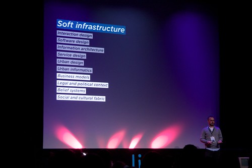
Dan Hill on the skill sets to develop and maintain soft infrastructures. All waiting for some serious cross-disciplinary pollination. Photo courtesy of Vlad Trifa
Posted: March 9th, 2009 | No Comments »
Most research focuses on the technological possibilities and problems of using tracking devices. Little attention is paid to the questions to what extend and in which manner knowledge developed through the use of new tracking technologies might influence spatial design and planning decisions. Therefore, there is a need to go beyond the collection of positioning data sets to the delivery of information and knowledge derived from these data. The Urbanism on Track expert meeting and book take that challenge with its chances, directions and limitations to explore how urban design and planning can embrace tracking technologies, particularly considering that recent studies on public space show urban designers ill capable of estimating the use of space (e.g. Golicnik 2005). So the opportunities to develop a learning loop with indicators and diagnostic tools in urban design and planning that can deal with contemporary urban complexity are present. Of course, spatial planning studies looking for such indicators is nothing new, but tracking technologies could complement these low-tech studies or replace traditional data collection methods such as travel diaries in time-use (my paper in submission “Detecting air travel to survey passengers on a worldwide scale” is an evidence of that).
The content and references of the 7position papers of the expert meeting provide a first glimpse in the ways to develop knowledge through the use of new tracking technologies (see particularly Klaasen, I.T. (2004) Knowledge-based Design: Developing Urban & Regional Design into a Science, Delft University Press, Delft – joining my observations on the urban microscopes and telescopes and the lack of science of what we see). I particularly found intriguing Monica Wachowicz‘ framework to representing different nature and sources of knowledge about people in motion. For instance she categorized movement metaphors of a spatial planning process in: the movement-as-trajectories, movement-as-journey, movement-as-activity, movement-as-urban forms (i.e. considering the constraint by urban forms – something that could be explored in New York)

Courtesy of Monica Wachowicz. Figure 1 illustrates the proposed multi-tier ontological framework, in which a successive set of tiers refine the steps of GKDD process, which are named as sampling, relating to a geographic context, discovering patterns, generating new insights, and confronting them with previous background knowledge. Therefore, five Tiers have been defined as Reality Space; Positioning Space; Geographic Space; Social Space; Cognitive Space.
References:
Golicnik, B (2005) Urban landscape between design practice, usage and reseach. Conference Life in the Urban Landscape. International Conference for Integrating Urban Knowledge & Practice Gothenburg, Sweden. May 29 – June 3, 2005
Relation to my thesis: a good set of references to bring more my paper on urban attractiveness, if it ever gets rejected. Also very useful for the “future work” section of my dissertation.
Posted: March 7th, 2009 | 1 Comment »
At last week’s Lift workshop on the The Design of the Hybrid City of the Near Future (more on that later…), I was surprised how much many participants really wanted to depict the visions of future cities (already studied 2 years ago) and then acted less engaged in dissecting the implications (e.g. the winners and losers, what if it goes wrong, what do we need to go right). There is a real fascination for these visions and I acknowledge that they are useful to maintain consistent progress towards betterment, but if we do not make an extra effort to consider their meanings, we are stuck in a) reflecting on our own visions of the future of the city b) fail to acknowledge the implications behind the improvements and their complexity. Without this exercise it seems that we keep on carrying the visions of the efficiently-built fabric, such as New Songdo or the Venus Project (video), where the city is built from scratch, optimized for non-human variables such as transportation efficiency and separated land use (e.g. EPCOT – video), away from distracting and messy people, very much in the 50s and 60s urban renewal fashion. We know how that turned out great! I am still wondering, how much has been learned from Jane Jacobs since then?

The designing the future video, a contemporary vision of an urban future free from distracting and messy people, by Jacque Fresco
Posted: March 5th, 2009 | No Comments »
On Tuesday, my work was presented in two different venue, in Hamburg at the GeoViz workshop on the Contribution of Geovisualization to the concept of the Digital City (thanks to Ayman Moghnieh for replacing me at the last minute!) and in Barcelona at Globalgeo in a forum on geoinformation and participation for sustainability (slides of the presentation). I stayed in Barcelona to meet some of the founders of the Vespucci Initiative and understand how my work integrates into the current trends and challenges in of geographic information science. Besides the acknowledgment of volunteer-generated information, it is still a very techno-driven field, that starts with technological capabilities of to collect, process and visualize data and after a few years having conference session with the title “So what?”. No doubt that this is one what that innovation happens, but I am always fascinated by the GIS community quest of the details (e.g. the perfect 3d models of a city) without much human perspective on “how good is good enough” and “for whom and what for”. Current concerns are rather on better organize the existing geospatial data (following the EU Inspire Directive), migrate them to Internet-based environments, make them ready for spatial analysis and visualization. In relation to that, spatial data should be considered as a medium, not a message. So far the community has overlooked the maintenance of the medium, for instance in failing in archiving data (e.g. we lack of the digital data from 10 years while we still still have analog data). In addition, there is paradigm shift that drives spatial analysis to show what is happening, not what it is, implying the development of 4d spatial analysis and visualizations systems.
The move into this Next Generation Digital Earth goes through the embracement of bottom-up spatial data infrastructures. Michael Goodchild made an effort in comparing the differences in quality, trust, timeliness and risks of volunteer generated information vs. authoritative information. He particularly talked about the contrast in the quality of the top-down (authority) data where inaccuracies are guaranteed and the bottom-up (assertion) data that tend to be more accurate in popular places (e.g. similar to Wikipedia). Therefore, authorities information must be verified through a process that can be slow. On the other hand, asserted information are generated in timely manner and people are willing to accept the false positive they generate (an angle that I could have explored in CatchBob). Through several examples (e.g. fire management in Santa Barbara), Goodchild showed the necessity to consider both accurate top-down information mixed with timely volunteer generation information (e.g. such as in Zagat). My work in New York certainly goes into that direction.
Posted: March 2nd, 2009 | No Comments »
Back from Lift09 with my traditional doggie bag (see Lift06, Lift07, Lift08) filled with food for thoughts and unlikely take-aways (all the videos are online).
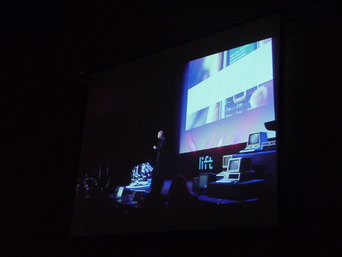
This year, I got the pleasure to moderate the “Towards a long here” session, a title inspired by Adam Greenfield’s concept of Long Here and Big Now. Carlo Ratti, Dan Hill and Anne Galloway shared their take on the challenges, problems and opportunities of the recombination of urban environments through technological advancements. First, Carlo Ratti gave a punchy rundown (fing’s notes) of the MIT SENSEable City Lab’s projects, with a nice homage to my tracing the visitor’s eyes. Each project provides an evidence that bits and atoms are coming together to reveal invisible urban dynamics (Real-time Rome, NYTE, World’s Eyes, Track Trash) and provide new types of experiences in urban space (WikiCity, Digital Water Pavilion). Without devaluating the importance of engaging visualizations of urban dynamics, Dan Hill (fing’s notes, Dan’s notes) showed evidences of the less happy marriage of soft and hard infrastructures from his frustrating 4-days journey to reach the northern hemisphere. It is when soft infrastructures “attack” (exception handling when rerouting passengers of a malfunctioning 747, lack of information system, smart card at the hotel not working) that we get the feeling of their importance (making me think to the Code/Space concepts). Bottom line: “it may not matter how good the hard infrastructure is, it is the soft infrastructure that affects how you feel“. Therefore, software infrastructures are not only about technology, it is also about software design, service design, interaction design, looking at the wider context of the organization, systems and people, urban design, urban informatics and even business models, the legal and political context, the belief systems and the social and cultural fabric. If we do not understand these aspects, we will make the same mistakes as past visions that relied on the fascination around the hard infrastructures and reducing cities to systems. When stepping back and considering the future with and understanding of why past vision never happened, it becomes clear that people (social, cultural, political such as privatization of properties) drive the evolution of cities, not technology (here I like to talk about co-evolution). Taking that into account, the exploitation of these soft infrastructure might lead to promising “super-powers” (here Matt Jones’ latest talk “The Demon-Haunted World” with the quote “the car changed the development of the city irreversibly in the 20th century. I’d claim that mobiles will do the same in the 21st” comes to mind): a) control of the transit network, not the other way around (e.g. visualization of Velib nodes revealing new movements in cities), b) ability to see the invisible activity, c) post-occupancy evaluation and feedback loops.

Dan Hill and the animated Velib nodes trick…
However the development of these “super-powers” and the improvement of the relationships between hard and soft might not come without a engaging the actors (I see using visualization as one way to stretch the imagination and engage into the action), b) user-centered design (the web industry could teach the architecture world, like the learned from product design and industrial design!), and c) Ove Arup’s “Total design” with an architecture team made of new disciplines such software engineers, interaction designers, sociologist, ethnographers, economists. Anne Galloway (fing’s notes), stepped away from a utilitarian discoursed and perfectly built on Carlo Ratti and Dan Hill’s suggestions, and the expressions of expectations, promises and hopes around these future cities and their informational membrane. If we consider the design of these cities and their positive aims as a gift (gift taken within its complex interaction): it might imply a gift back (uneven expectations), it might not be well interpreted (like any awkward gifts). So if we offer citizen better awareness of the city dynamics and power to influence the city evolution, does not mean they will accept the gift. Indeed, taking the example of citizen-science and people-centric sensing, citizen might just not be interested in the collect of the data, it might increase the divide between the people who are able to participate and the ones who don’t (as discussed in The rise of the sensor citizen).
Some speakers discussed the study of failures (Nicolas Nova) and the acknowledgment of chaos (Fabio Sergio discussed that hope and dreams carried in design only show a perfect world, a world that does not exist, and then had the necessary slide on the Napoli garbare issue) as part of the design process. It was music to my hears after talking about seamful design and mesiness at lift07.
A workshop on the design of hybrid cities of the near future also took place. More on that later…
Once again, the Lift Conference outdid itself, a conference that has the self-confidence to take chances in inviting unlikely but refreshing speakers (Baba Wamé, Frank Beau) mixed with safe bets that always deliver beyond expectation (Matt Webb, Fabio Sergio, Dan Hill, Anne Galloway…) and open stages with a smart sense of provocation like Bill Thompson’s the death of privacy or inspiration with Felix Koch and Fabian Keller on the literacy of cutting. Lift is THE conference of the World-Wide Lab, the best hybrid forum out there. There is still a need to work on the workshops formats to get back to lifto6′s level.
Once again, my hat is off to the organizers!
Fabio Sergio at Lift Conference 2009