Reformulating the co-evolution of taxi drivers and their in-car navigation systems
Posted: March 13th, 2009 | 1 Comment »To complete my PhD dissertation that will be based on a series of papers, I am writing a journal version of my study presented at last year’s AAG: The co-evolution of taxi drivers and their in-car navigation systems. Besides improving the details that describe the research method, I need to rephrase the elements of co-evolution I aimed at capturing, re-categorize the findings and work on a discussion section that compares the findings with related works and link them to implications consideration for design. A revamp I dissect below.
Motivations
The extensive distribution of satellite navigation systems represents the first massive adoption of location-aware system by the public. However, the market success also translates into documented poor integration of the technology into the practice of driving (e.g. distractions that create accidents, frustrations due to the uneven quality of the geoinformation). From this observation, we hypothesize that users of satellite navigation systems overcome these types of problems by both adapting to their systems and adapting their systems to their needs. First we wanted to report on evidences of this co-evolution (theorized in Orlikowski, 1992a; O’Day, Bobrow, Shirley, 1996, Ackerman, 2000) and then describe the detected implications (e.g. (de-)skilling factors on the knowledge of the city and social relationships, modification of the wayfinding practice, new relations to the environment). An ethnographical approach provides an appropriate analytic angle to examine user practices in context and situated activities (need stronger arguments here!). We argue that our observations and interpretations can be valuable to designers of next generation location-aware systems particularly to understand how a) users create over time unanticipated use to better fit their need, if the system is capable of only partial satisfaction; b) a location-aware system effects the interaction of the user with their environment (social, physical, informational); c) the implication of the adoption of location-aware system on potential for future design. An example in Hutchins cognition in the wild is the slow evolution of navigational tools. For example, the Mercator projection for maps simplifies navigation calculations, and its creation was an act of tool adoption and co-evolution.
Phases of co-evolution
We analyzed this co-evolution for three different phases
- Acquisition: why and how this new technology gets integrated into other artifacts and how, over time, it impacts the use of these artifacts;
- Expectation gap: how the reasons to acquire are matched in practices and where are the expectation gaps;
- Evolution of the appropriation: despite the gaps, how does the practices evolves in relation a) to the awareness and reactions to the limitations and imperfections of the system; b) to driver’s knowledge of the environment; c) to the access to geoinformation both from the system and other artifacts.
Approach, method and participants
So the market success of makes relevant phenomenon to study how people integrate pervasive geoinformation into their practices in the context of their work. What was even more appealing was to perform a systematic study of one type of early adopters, the taxi drivers in Barcelona (available in a large number of the 10,400 licensed cars), who have massively adopted the technology the last few years. This context is precisely relevant to the research on location-based systems because it provides evidences, outsides of the laboratories of their impact and implications, we believe necessary to feed the design process. The study of in-car navigation systems are typically interested in usability issues with an experimental angle. Rather than focusing on the device, we are interested on the practice with mobile and location-aware devices (see Understanding mobility contexts), on the losses and opportunities, and considering a full-circle perspective (Chrisman, 2005)
In our ethnographically-inspired study, we collected empirical evidences from 12 taxi drivers (11 males, 1 female) with a working experience from 2 to 20 years. In a first phase, we conducted semi-structered interviews at the Barcelona airport parking lot dedicated to taxis. This site provided a good setting to get in touch with taxi drivers, because they often must wait there for more than 30 minutes. During this period, they fill the time discussing, playing (e.g. chess, scrabble, golf), cleaning their care, taking a refreshment and eating. The navigation system had been purchased and used by the informants for a least 6 months. Interviews alone did not suffice, as the informants necessarily selective in what they describe or think is important to discuss. Therefore, they complement additional situational insights from observation of driver work settings (e.g. artifacts used) and behavior (e.g. engagement with geoinformation) while driving. Acting is customers, we requested rides from and to a railway station, a major hotel and an address on one of the many very narrow streets of the Gracia neighborhood. Each informant participated in one session, lasting approximately in from 45 minutes to 1 hour, divided in half with situational insights then complementary semi-structured interviews in the other half.
Despite the small sample of taxi drivers, we were able to collect rich data consisting of photos of work settings (to record the eco-system of artifacts), videos of taxi rides (to capture key moments of access to geoinformation) and written field notes from the semi-structured interviews (analyzed and compacted after each session). In our analysis consisted in a careful reading of the different materials and highlighting parts that were related to the phases of the co-evolution we wanted to focus on. We organized the relevant parts into common themes, and coded the documents using the emerging themes. The sessions were conducted in Spanish and we provide the closest translation for this paper. We summarize the findings extracted from these themes in the following section.
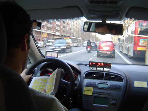
After a red light, in proximity to destination, a taxi driver is about to close his “Guia” after checking the location of a street number. The navigation system is in passive mode.
Findings
Addition to an existing ecosystem of artifacts
The navigation system completes an arrangement of artifacts proving layers of geoinformation to support the job. With our observations, we were able to categorize detected the real-time information sources with the sat-nav system, dispatched radio, electronic booking system, mobile phone and radio. Another category of artifacts provide more static information of the city; the newspapers to keep the knowledge of events and activities in the city up to day, scribbled list of “unofficial” points of interests requested by customers such as the strip clubs, and above all the street directory and map of Barcelona “Guia Urbana de Barcelona” generally kept at reach on the passenger seat, above the dashboard or the interior storage compartment. (Need a table to describe the artifact, its purpose, context of use and the evolution of this ecosystem.
Serenity over efficiency
In the past, taxi drivers face moments of uncertainty when a customers take them to a village or unfamiliar areas of Barcelona, such as the multiple suburban business areas that emerged from the ground in the recent years. Nowadays, there is a consensus that a satellite navigations system is an unbeatable tool when it come to reaching a specific destination in a village and leaving it and it is a strong reason for purchase. But it is not really to be more productive and hence earn more, rather than feeling more serene in appropriately doing their job. A tool not to make more money, nor to improve the efficacy, but to tranquilize, ”I can go everywhere and relax” said informant X and “the fear of getting lost with a customer I felt in my stomach now disappeared” (informant Y). Other drivers mentioned that it does not only tranquilize them but also their customers ”they know I cannot cheat them with it”, “it reassures them that I go to the proper destination”. This feeling of relying on a “companion” for critical situations reveals particularly when informants referrer to it as a “he” (and their car as a “she”). That does not prevent them in keeping it most of the time in the glove compartment and retrieving it only the times it is necessary.
The phases of wayfinding
The wayfinding practice takes place in 2 main phases. For the “to go” phase in which the driver takes the proper direction and the “to arrive” phase in which the precise drop off location (the number of the street, a monument, a corner) necessitate different geoinformation at a different granularity. [...] For a ride to a rather unknown destination, drivers seem to accesses the geoinformation as in a “funnel”. First, there is a tendency to quickly retrieve in the paper-based street directory the area of the destination point. If the paper map does not provide enough information such as reference points to precisely arrive at the area, the drivers we observed engage with the navigation system. No detailed information are requested at that moment of the ride. It is only when approaching the destination area, that the exact address in the navigation system is entered. Informant X explained that he engages with the system at that moment to avoid the often misleading information on the path to take. Indeed, a taxi driver applies several paths depending on the time of the day and circumstances (e.g. traffic, weather conditions, preference of passenger).
An altered learning process
In the past, the driver would open the “Guia” and browse the index of streets and points of interest to get access to a map of the area comprised by the destination. The book was one way to learn the city by doing. Another big part of the knowledge drivers acquire come from the customers themselves, as they communicate the tricks and secrets that official books and commercial systems do not disclose. As the experience drivers contain most of the knowledge of the city in memory they rarely return to the Guia. In fact, they prefer using their sat-nav and open the Guia only as fail-over (e.g. when the system does not contain a street number or lacks of information). Even after 20 years of experience, one drivers still perceived reading the Guia as a demanding task. Compare to that, “hitting the screen of his Tom-Tom is a pure pleasure“. Experienced drivers only rely in the system (sometimes keeping it in the glove compartment – or only use it to keep track of their speed) when driving to unfamiliar destinations, which after 20 years only happens rarely. The system is not source of learning but rather a punctual saver.
The integration of the satellite navigation system altered the learning process of the city from three main disruptions: the necessity to assess the quality of the geoinformation, the imputation of some social interactions and the ability to temporarily disengage with the environment:
- Assessing the quality of geoinformation
Taxi drivers with a short job experience express mixed feelings about their experience with their sat-nav ”It is like my mobile phone, sometimes it does not work well”, “it is a potential problem” in terms of quality of services and precision of the information. Their demand of accurate information quickly reached the limits of the systems and the inaccuracy of the system directly impacted the quality of their service. Because they had to deeply rely on it in the beginning, they have learned when not to rely on it. For instance, informant X could name me the places where he experienced the navigation information to be absolutely irrelevant (e.g. get access major squares). But that does not make them learn the city. In consequence, they embrace the use of the “Guia” which is “more accurate and complete” for their job, particularly when it comes to providing a detailed index of streets, points of interest and city-related information.
- New engagement with the environment
As drivers cannot completely rely on their navigation system, they have to form their knowledge of the city to improve quality of their service and relax. One mean translated into leaving their navigation system system on passive mode to learn the street names or identify the present of fixed speed measurements radars as they appear on the screen. Keeping the system on passive mode, also enables the driver to disengage with the environment for a while knowing that the screen will give a proper position. In the past, drivers would count the number of streets to cross before making a turn.
- Social amputation
A major part of about learning about the city comes from the interaction with the customers. It is still a tradition for a taxi driver to ask “how do you want to go there?” and rely on the direction given by the customers to avoid any complains and learn the tricks to navigate. The presence of a navigation system changes this social configuration and reduces the opportunities for this learning process to take place. This technological presence not only affects the social interactions not only inside the car, but also with remote friends and colleagues. Informant X was relieved that he did not have to use his radio to ask colleagues about particular location information and directions (even though many taxi drivers are social animals). Similarly, taxi drivers have now less a tendency to ask for directions to locals (e.g. in remote villages) or other knowledgeable people of the city (e.g. truck drivers at red lights in industrial areas).
Discussion
- De-skilling?
Previous studies on navigation systems have highlighted that introduction of navigation system has shown evidences of de-skilling effect on orientation and navigation (Leshed et al., 2008, Elaluf-Calderwood and Sørensen, 2008, Aporta and Higgs, 2008). For instance “The more the driver relies on the system to locate jobs, the less he or she relies on their in-depth knowledge of where they need to position themselves to maximise income” ( Elaluf-Calderwood and Sørensen, 2008). This is also supported by the perception of the experienced generation of taxi drivers we got to observe and interview. Informant X explained that “the newcomers who use a navigation system do not gain knowledge of the city, because they follow the recommendations and stop to think“. Our analysis of of the less knowledgeable taxi drivers showed somehow has not revealed negative affects on their acquisition of knowledge that support their skills to perform well their job. We notices that they are eager to learn the city and the imperfection of their systems forced them to learn using traditional sources such as the “Guia”. These drivers have a tendency to keep their system passive mode, not only to detach with the orientation process but also to learn the environment in familiar areas such as keeping track of the street names and their sequences.
This need by less experience drivers to access multiple sources of information from an ecosystem of artifacts slightly breaks the myth that sat-nav system changes a “skilled” job unto a unskilled one; in other words anyone with a GPS could do their job. A prove as that the system gets to be used less and less over time, sometimes finishing in the glove compartments or even the trunk. However, the presence of the technology altered the social practices that were at the source of learning the “unofficial” city from the knowledgeable customers. In that sense taxi drivers may slowly change social practice to adapt, but we have no evidences of that. What is clear is that the navigation system does not provide these kind of information.
- Information quality, system limitations and co-evolution
The fluctuating quality of the geoinformation as sources of co-evolution of the taxi drivers and their in-car navigation system. An ecosystem of artifacts are set to complement the limitations of information. Indeed, taxi drivers learned not to completely rely on their sat-nav because they do not have the knowledge to assess the quality of the information. Therefore, besides learning to interpret the system and its inaccuracies, they have a tendency to open their “Guia”. Informant X admitted that when a conflict emerges between his sat-nav and his intuition he starts to “improvise” and depending on the circumstances he would either switch it off or ignore it for a while, a pure example of Suchman’s situated action theory (locations and opportunity determine the action): “Idiosyncrasy, improvisation and knowledge are all useful tools when choices between planned and situation acts are complex” (Suchman, 1987)”
- Considerations for design
* Moving beyond technological determinism
* People may use systems in ways unanticipated by the designers (more evidences for the discourse of Ackerman). For instance, one taxi drivers used the speed displayed in the navigation system rather than fixing his broken speedometer.
* System designers should assume that people will try to tailor their use of in-car navigation systems; a system that complements rather than replace an ecosystem of artifacts, sources of the knowledge of the city. It does not replace, because a large part of the knowledge has no informational model or digital sources.
* Support and not reduce social interaction with customers as opportunities to learn: often a taxi ride is an opportunity to engage in social interactions. A navigation system is primarily designed for a specific interaction with the driver without engaging with other people in the car, secluding the customer.
* Highlight the quality of the geoinfomation to help users to match their knowledge to assess the quality of geoinformation. This is particularly importance with the emergence of real-time traffic information. So the design should reveal the quality and timeless of the information (seamful design)
Relation to my thesis: Using this blog to reformulate a paper for journal submission (that should be my last journal paper) in re-aligning the thoughts free from the academic paper writing overheads
I was wondering if you will relate your conclusions to the work of von Hippel on user-led ‘innovation’? I was struck by how your notes reveal your caste study group as an ‘innovation community’ (following vin Hippel’s 2005 terminology – http://web.mit.edu/evhippel/www/democ1.htm). Also, if we are to move ‘beyond technological determinism’ then following Latour (1993) we need to take the role of ‘things’ (such as the GPS, the Guia and the car) seriously in formulating our accounts, not as the motivating factors (driving behaviour), but as co-constituting the assemblages under observation, as in your rendering of the ‘co-evolution of the taxi drivers and their in-car navigation system’. I look forward to reading more as the conclusions develop.