Presentation at the Day on Geographic Information of the Balearic Islands
Posted: December 4th, 2008 | No Comments »My work on the collection and analysis of digital footprints was presented by proxy (Josep Blat) in Mallorca at the Jornada d’informació geogràfica de les Illes Balears (program) in Mallorca. The talk in catalan Petjades digitals, dinàmiques urbanes i turístiques the new types of dynamic urban data and their potential application in urbanism (evidence-based urbanism, remote-control urbanism and post-occupency evaluation) and tourism (novel perspective to reveal density, flows and experience of visitors in a city or region); or in catalan:
A les nostres ciutats podem trobar un munt de nous dispositius digitals com càmeres de control del trànsit, sensors de pollució, xarxes inalàmbriques, telèfons mòbils, càmeres de fotos digitals, etc. L’objectiu de la nostra recerca és aprofitar la informació d’aquests nous elements per observar els processos urbans. Els resultats tenen aplicacions directes en els àmbits de la planificació urbana, el transport o el turisme. Especialment rellevants en el cas de les Illes Balears són els mètodes que permeten identificar els moviments dels turistes. Saber quins indrets visiten, com i quan, suposa una valuosa informació per a les autoritats locals i regionals i per als diferents agents del sector.
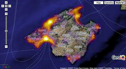
The island of Mallorca was one of my first case study, with GeoIQ as a tool to quickly visualize density data (here photographers).
Thanks to Toni Navarrete for the invitation!
Relation to my thesis: communicate my work to practitioners and as a result receive feedback and understand their current problematic. For instance, Mallorca needs novel insights the environmental impact of the occupation density of its beaches and the recreation boats in their proximity. Practitioners consider that the collection of digital footprints would represent an indirect method to valuably measure this occupation.