Embracing the Subjectivity of Georeferenced Photos
Posted: May 26th, 2010 | No Comments »Since Tracing the Visitor’s Eye, back in 2007, several projects have emerged with more stunning and large scale maps of georeferenced photos in Flickr, Picasa, Panoramio or Getty Images. Some visualize the density of photos to describe the spaces (e.g. World touristiness map, Mapping the Cultural Buzz, 24 Hours of Geotagged Photos) while other exploit the timestamp embedded in each photo EXIF to extract individual paths (e.g. Mapping the World’s Photos, Image Sequence Geolocation with Human Travel Priors), flows (e.g. The World’s Eyes) and even infer the mode of transportation (e.g. The Geotaggers’ World Atlas).

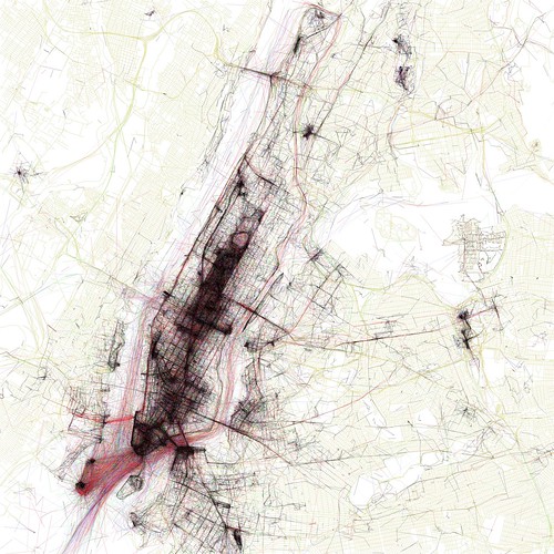
New York City from Eric Fischer‘s beautiful Geotaggers’ World Atlas.
These works display the enormous creative skills and sense of aesthetics of their developers. In a pure “urban demo” approach, their storytelling power serves as alibi to attract attention, stimulate the dialogue and stretch the imagination (see Below the Tip of the Urban Data Iceberg).
Yet, a second generation of exploration of these georeferenced photos has yet to take place; the type of investigation that creates value and knowledge beyond a pure narrative and the fascination of beautiful visualizations. I explain this slow evolution to extract ourselves from.
First, some of the narratives describing these projects aim for objectivity rather than fully embracing the subjectivity of the data. In my research work, I considered that uploading, tagging and disclosing the location of a photo was an act of communication rather than a pure implicit history of physical presence. Therefore, these data are not comparable to absolute values of the presence of photographers and tourists as it is easy and useful to narrate with these visualizations. Rather, the data give indications about the places/events/environments web-sharing platform like sharing. An example of knowledge extraction from georeferenced data is Neighborhood Boundaries by Tom Taylor that exploit Flickr Shapefiles to define neighborhoods from human perceptions.
Second, these works do not place under scrutiny the evolution of subjective layers or digital strata accumulated over the last years. When samples are extracted, cleaned, normalized and analyzed, they can give indications on the evolution of places/events/environments. Our work in the Summer 2008 around the NYC Waterfalls come to my mind to exemplify the value of temporal layers (see Quantifying urban attractiveness from the distribution and density of digital footprints). In this work, we compared over 3 years the flows photographers present in lower Manhattan. With a centrality indicator, we could reveal that the year of the Waterfalls, the waterfront became more central in the routes based on what photographers like to share. This work delivered a quantifiable indicator to evaluate an urban strategy extracted from a subjective dataset.
Why do I blog this: Noticing a surge of new visualizations of georeferenced photos, when the moment might have come to produce a new generation of investigation, to create and share knowledge out of theses masses of data. It will be the theme of the upcoming Lift France 10. The ability to attract the attention with visualizations is part of the new data scientist skillset. On the other hand, grasping the value in subjective data is still a concept we must get our mind around. To be discussed at Lift in Marseille.

