Autodesk's Digital Cities Initiative
Posted: July 28th, 2008 | No Comments »Autodesk officially launched their Digital Cities initiative with a first pilot in Salzburg. Their approach relies on a shared 3D collaboration and visualization environment for data from architectural models, utility networks, transportation networks. The aim is to foster a holistic approach to city management from engineering-level models to visualize, analyze, and simulate the real world. In an interview on the initiative, Doug Eberhard, Autodesk’s senior director for digital cities highlights the importance of this approach to communicate early in project:
The current process has been called the DAD method (decide, announce, defend), but that’s changing. By communicating early and often, you eliminate a lot of backlash. Digital cities allow you to share projects with the public in a robust and meaningful way.
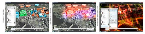
Snapshots of the Digital Cities Metropolis demos
Update: Doug Eberhard “Digital Cities” presentation at Where 2.0.
Relation to my thesis: A corporate vision on the management of hybrid cities (see also Arup’s Future of Connected and Sustainable Cities). I wonder if the move from 2D to 3D and 4D provides better perspectives to collaborate and take decisions. From my experience, novel urban visualization based on more social data than the ones handled by Autodesk have a real added-value for local authorities to communicate and reveal some invisible aspect of a city (such as in Florence). However, the fluctuating quality in the data often still not taken into consideration in the visualization often prevent from decisions to be taken. Bad or missing data also come from the current unsustainable digital practices in cities. I have noticed several time that agencies don’t share information or we share it in unsustainable ways.