The Route 66 Example
Posted: July 21st, 2008 | No Comments »I stumbled upon this video of Eric Rodenbeck’s presentation at Postopolis! who chronologically describes Stamen’s projects (see also Dan Hill’s notes and a past presentation with Tom Carden on Visualizing Urban Data). In Mappr, they experimented the geottaged photos on Flickr to extract meaing from the tags that contain location information (representing 40% of the tags by then). For instance Route 66 draws itself from the rich dataset. Along the same vein, in a recent presentation at MIT, (ex-)Yahoo! Research Berkeley Mor Naaman employs the same “Route 66″ example to show emerging patterns from a social media perspective (see slides How Flickr Helps us Make Sense of the World)
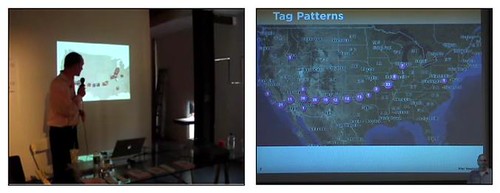
The Route 66 example, Eric Rodenbeck (left), Mor Naaman (right)
Relation to my thesis: I have certainly inspired from from Stamen projects on visualizing urban data and Yahoo! Research Berkeley legacy on the studying geotagging practices and extracting patterns from the data, even though eventually we do not share the same goals.