 So
far the investigation of spatio-temporal patterns of people
mainly
rendered a quantitative understanding of the city. In our study, we
intend to leverage implicit spatio-temporal data (i.e. latitude,
longitude and timestamp) with the richness of people-generated
information. Our approach is to consider that uploading, tagging and
disclosing the location of a photo can be interpreted as an act of
communication rather than a pure implicit history of physical presence.
For this purpose, we retrieved from Flickr, large amounts of photo
taken by thousands of users in the world’s most photographed
cities. Based on the time, explicit location and people’s
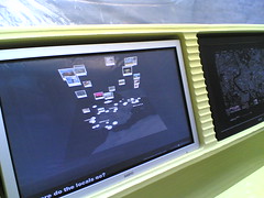
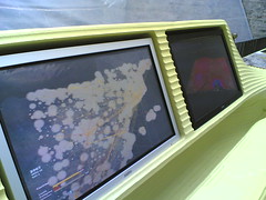
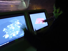
description of their photos, we design geovisualizations. They reveal
patterns of tourists and citizens consuming a city, such as the flow of
people between city attractions (see figures below), the monuments
areas of influence or what is happening with day/night and
working/weekend periodicity. As a result, we are
So
far the investigation of spatio-temporal patterns of people
mainly
rendered a quantitative understanding of the city. In our study, we
intend to leverage implicit spatio-temporal data (i.e. latitude,
longitude and timestamp) with the richness of people-generated
information. Our approach is to consider that uploading, tagging and
disclosing the location of a photo can be interpreted as an act of
communication rather than a pure implicit history of physical presence.
For this purpose, we retrieved from Flickr, large amounts of photo
taken by thousands of users in the world’s most photographed
cities. Based on the time, explicit location and people’s
description of their photos, we design geovisualizations. They reveal
patterns of tourists and citizens consuming a city, such as the flow of
people between city attractions (see figures below), the monuments
areas of influence or what is happening with day/night and
working/weekend periodicity. As a result, we are
- evaluating the potential of using people-generated geotagged information to contribute urban understanding.
- studying how people explicitly position and disclose spatio-temporal information in order to understand their use and need of quality of location information in a urban space.
Urban computing generally encompasses the study of people experiencing the city with technologies. Our approach is to benefit from people’s experience of these services, to gain a more thorough understanding of urban environments. In the recent years, the large deployment of mobile devices led to a massive increase in the volume of records of where people have been and when they were there. The analysis of the accumulated archives of such spatio-temporal data can derive high-level human behavior such as the estimation of mobility mode. Evidently, urban planers, traffic engineers, tourism authorities could profit from the pervasive deployment of new technologies to increase the understanding of how people and crowds explicitly consume space.
We perceive three main domains of applicability of the processing and visualization of these massively collected personal logs, traces (i.e. history of previous locations):
- Provide urban planners, transport authorities and traffic engineers with data to refine their models of citizens spatio-temporal behaviors.
- Bring new perspective for decision making and policies building.
- Raise awareness and affect the discussion making of
individuals or of a crowd.
This project targets objectives at three levels, that would be considered as the three main scientific contributions:
First, evaluate the potential of using people-generated geotagged information to contribute urban understanding. Therefore, we have built a framework to collect and analyze spatio-temporal data in urban spaces based on user-generated content. The experiment takes anonymous flickr users exploring cities as context.
Second, analyze how Flickr users take advantage of the accuracy feature to geotag their images (where, what, when, history of use, overall usage over time). By studying how people disclose location information, we aim to understand the level of location information quality and timeliness must be delivered in order to be useful and relevant?
Third, explore the parameters that influence successful uncertainty visualization. The many sources of error and imprecision in the sensed data impact the quality and timeliness of the spatio-temporal data. By integrating the notions of spatial uncertainty in people-movement maps/visualizations, we evaluate techniques to visualize spatio-temporal data revealing their inherent uncertainty.
Visual experiments


Public exhibition
Los Ojos del Mundo (The World's Eyes) featured at the Disseny Hub Barcelona between December 2008 and May 2009
Publications
Girardin, F., Calabrese, F., Dal Fiore, F. , Ratti, C., and Blat, J. (2008). Digital footprinting: Uncovering tourists with user-generated content. IEEE Pervasive Computing, 7(4):36–43.
Girardin, F., Vaccari, A., and Ratti, C. (2008). Uncovering the presence and movements of tourist from user-generated content. In 9th International Forum on Tourism Statistics, Paris, France.
Girardin, F., Fiore, F. D., Ratti, C., and Blat, J. (2008). Leveraging explicitly disclosed location information to understand tourist dynamics: A case study. Journal of Location-Based Services 2, 1, 41–54.
Girardin, F., Fiore, F. D., Blat, J., and Ratti, C. (2007). Understanding of tourist dynamics from explicitly disclosed location information. In The 4th International Symposium on LBS & TeleCartography.
Girardin, F. and Blat, J. (2007). Place this photo on a map: A study of explicit disclosure of location information. Late Breaking Result at Ubicomp 2007.
Girardin, F., Blat, J., and Nova, N. (2007). Tracing the visitor’s eye: Using explicitly disclosed location information for urban analysis. IEEE Pervasive Computing, 6(3):55.
Contacts
Fabien Girardin and Josep Blat
Interactive Technologies Group
Pompeu Fabra University
Passeig de Circumval·ació, 8
08003 Barcelona, Spain [Map]
E: fabien dot girardin (at) upf dot edu
W: www.girardin.org/fabien/
Copyright © 2007, Fabien Girardin